| Holborn | |
|---|---|
 | |
Location within Greater London | |
| Population | 13,023 (2011 Census. Holborn and Covent Garden Ward)[1] |
| OS grid reference | TQ310818 |
| London borough | |
| Ceremonial county | Greater London |
| Region | |
| Country | England |
| Sovereign state | United Kingdom |
| Post town | LONDON |
| Postcode district | WC1, WC2 |
| Postcode district | EC1 |
| Dialling code | 020 |
| Police | Metropolitan |
| Fire | London |
| Ambulance | London |
| UK Parliament | |
| London Assembly | |
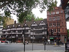
Holborn (/ˈhoʊbərn/ HOH-bərn or /ˈhoʊlbərn/[a]), an area in central London, covers the south-eastern part of the London Borough of Camden and a part (St Andrew Holborn Below the Bars) of the Ward of Farringdon Without in the City of London.
The area has its roots in the ancient parish of Holborn, which lay on the west bank of the now buried River Fleet;[2] the district takes its name from an alternative name for the river: the Holbourne (or Oldbourne). The area is sometimes described as part of the West End of London[3][4] or of the wider West London area.
The River Fleet also gave its name to the streets Holborn and High Holborn which extend west from the site of the former Newgate in the London Wall, over the Fleet, through Holborn and towards Westminster.
The district benefits from a central location which helps provide a strong mixed economy. The area is particularly noted for its links to the legal profession, for the diamond centre at Hatton Garden and for Great Ormond Street Hospital.
- ^ "Camden Ward population 2011". Neighbourhood Statistics. Office for National Statistics. Retrieved 20 October 2016.
- ^ Temple, Philip (2008). "'West of Farringdon Road', in Survey of London: Volume 47, Northern Clerkenwell and Pentonville". London: British History Online. pp. 22–51. Retrieved 31 July 2020.
- ^ "West End Project Overview" (PDF). London Borough of Camden. Archived (PDF) from the original on 2 September 2018.
- ^ "Case Study" (PDF). London Borough of Camden. Archived (PDF) from the original on 18 June 2021.
