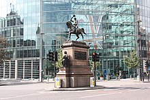
| Holborn Circus | |
|---|---|
 Holborn Circus pictured in 2012 | |
 | |
| Location | |
| London, United Kingdom | |
| Coordinates | 51°31′03″N 0°06′27″W / 51.5176°N 0.1075°W |
| Roads at junction | High Holborn (eastern part also named Holborn Viaduct); Hatton Garden, Charterhouse Street, New Fetter Lane, |
| Construction | |
| Type | Intersection |
| Opened | 1867 |
Holborn Circus is a five-way junction at the western extreme of the City of London, specifically between Holborn (St Andrew) and its Hatton Garden (St Alban) part.[1] Its main, east–west, route is the inchoate A40 road. It was designed by the engineer William Haywood and opened in 1867.[2] The term circus describes how the frontages of the buildings facing curved round in a concave chamfer. These, in part replaced with glass and metal-clad buildings, remain well set back.
The place was described in Charles Dickens' Dictionary of London (1879) as "perhaps... the finest piece of street architecture in the City".
- ^ Map of Holborn St Alban
- ^ "Holborn Circus, London". The Victorian Society. 17 October 2012. Retrieved 3 August 2013.