| Holter Dam | |
|---|---|
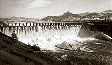
 Holter Dam in 1918 | |
| Official name | Holter Dam |
| Location | Lewis and Clark County, Montana, U.S. |
| Coordinates | 46°59′30″N 112°00′21″W / 46.99167°N 112.00583°W |
| Construction began | 1908 |
| Opening date | 1918 |
| Operator(s) | NorthWestern Corporation |
| Dam and spillways | |
| Impounds | Missouri River |
| Height | 124 feet (38 m) |
| Length | 1,364 feet (416 m) |
| Reservoir | |
| Creates | Holter Lake |
| Power Station | |
| Installed capacity | 50 MW |
| Annual generation | 319,800,000 KWh (2009)[1] |
Holter Dam is a hydroelectric straight gravity dam on the Missouri River about 45 miles (72 km) northeast of Helena, Montana, in the United States.[2][3] The dam, which was built between 1908 and 1918, is 1,364 feet (416 m) long and 124 feet (38 m) high.[2][3] The reservoir formed by the dam, Holter Lake (also known as Holter Reservoir) is 25 miles (40 km) long and has a storage capacity of 243,000 acre-feet (300,000,000 m3) of water when full.[4] The dam is a "run-of-the-river" dam because it can generate electricity without needing to store additional water supplies behind the dam.[4][5]
- ^ "Holter". Carbon Monitoring for Action. Retrieved 2018-04-26.
- ^ a b Aarstad, et al., Montana Place Names From Alzada to Zortman, 2009, p. 125.
- ^ a b Upper Missouri River Reservoir Fisheries Management Plan, 2010-2019, Montana Department of Fish, Wildlife and Parks, May 13, 2010, p. 11.
- ^ a b Upper Missouri River Reservoir Fisheries Management Plan, 2010-2019, Montana Department of Fish, Wildlife and Parks, May 13, 2010, p. 9.
- ^ Badovinac, Fly Fishing: Montana's Missouri River, 2003, p. 17.