Holuhraun | |
|---|---|
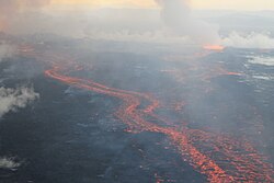
 The Holuhraun lava field, on 4 September 2014, during the 2014 eruption | |
| Coordinates: 64°51′N 16°50′W / 64.85°N 16.83°W | |
| Location | Suður-Þingeyjarsýsla, Northeastern Region, Iceland |
| Topo map |  Geological features near Holuhraun with the source of the lava being the Bárðarbunga central volcano outlined in red. The 2014 Holuhraun lava flow is a deep shade of purple, the 1797 Holuhraun lava flow is shaded slightly lighter, while other older Bárðarbunga associated lava flows are light purple. Shading also shows: calderas, other central volcanoes, fissure swarms, subglacial terrain above 1,100 m (3,600 ft) and seismically active areas between 1995 to 2007. Clicking on the image enables full window and mouse-over with more detail. |
Holuhraun ([ˈhɔːlʏˌr̥œyːn] ) is a lava field just north of the Vatnajökull ice cap, in the Icelandic Highlands, in Suður-Þingeyjarsýsla, Northeastern Region, Iceland. The lava field was created by fissure eruptions.[1] After a research expedition in 1880, the lava field was initially called Kvislarhraun [ˈkʰvɪstlar̥ˌr̥œyːn]. Four years later, it received its current name from geologist and geographer Þorvaldur Thoroddsen.[1]
Holuhraun was the site of a volcanic eruption which began on 29 August 2014 and produced a lava field of more than 85 km2 (33 sq mi)[2] and 1.4 km3 (0.34 cu mi) – the largest in Iceland since 1783.[3]
- ^ a b "Holuhraun". Nordic Adventure Travel. Archived from the original on 30 August 2014. Retrieved 29 August 2014.
- ^ Geiger, Harri; Mattsson, Tobias; Deegan, Frances M.; Troll, Valentin R.; Burchardt, Steffi; Gudmundsson, Ólafur; Tryggvason, Ari; Krumbholz, Michael; Harris, Chris (2016). "Magma plumbing for the 2014–2015 Holuhraun eruption, Iceland". Geochemistry, Geophysics, Geosystems. 17 (8): 2953–2968. Bibcode:2016GGG....17.2953G. doi:10.1002/2016GC006317. ISSN 1525-2027. S2CID 132951014.
- ^ "Over 1 km3 of lava erupted at Holuhraun". Archived from the original on 13 November 2014. Retrieved 13 November 2014.
