Homer, Ohio | |
|---|---|
Unincorporated community | |
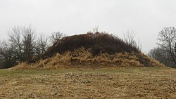
 Dixon Mound, built by the Adena culture, on the community's western side | |
 Location in Licking County | |
| Coordinates: 40°15′10″N 82°31′04″W / 40.2528414°N 82.5176626°W | |
| Country | United States |
| State | Ohio |
| County | Licking |
| Elevation | 991 ft (302 m) |
| Time zone | UTC−5 (Eastern (EST)) |
| • Summer (DST) | UTC−4 (EDT) |
| ZIP code | 43027[2] |
| GNIS feature ID | 1064854[1] |
Homer is an unincorporated community in northern Burlington Township, Licking County, Ohio, United States. [2] It lies along State Route 661 between Granville and Mount Vernon.

