| Hong Kong UNESCO Global Geopark | |||||||||||
|---|---|---|---|---|---|---|---|---|---|---|---|
| Traditional Chinese | 香港聯合國教科文組織世界地質公園 | ||||||||||
| Simplified Chinese | 香港联合国教科文组织世界地质公园 | ||||||||||
| |||||||||||
| Hong Kong National Geopark | |||||||||||
| Traditional Chinese | 香港國家地質公園 | ||||||||||
| Simplified Chinese | 香港国家地质公园 | ||||||||||
| |||||||||||


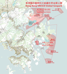
Hong Kong UNESCO Global Geopark (Chinese: 香港聯合國教科文組織世界地質公園), formerly Hong Kong National Geopark (香港國家地質公園), was inaugurated on 3 November 2009. It is a single entity of land area over 150 km2 across parts of the eastern and northeastern New Territories.[1] On 18 September 2011, UNESCO listed the geopark as part of its Global Geoparks Network.
The Hong Kong UNESCO Global Geopark consists of two geological regions:[2]
- the Sai Kung Volcanic Rock Region, with its widely distributed tuff volcanic rocks displaying prismatic columnar jointing, which are of international geological significance
- the Northeast New Territories Sedimentary Rock Region, which comprises sedimentary rocks formed in different geologic periods, showcasing the complete geological history of Hong Kong.