This article needs additional citations for verification. (March 2007) |
Hood River County | |
|---|---|
 Hood River County Courthouse in Hood River | |
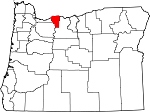
 Location within the U.S. state of Oregon | |
 Oregon's location within the U.S. | |
| Coordinates: 45°31′03″N 121°38′58″W / 45.5175°N 121.64944444444°W | |
| Country | |
| State | |
| Founded | June 23, 1908 |
| Named for | Hood River |
| Seat | Hood River |
| Largest city | Hood River |
| Area | |
• Total | 533 sq mi (1,380 km2) |
| • Land | 522 sq mi (1,350 km2) |
| • Water | 11 sq mi (30 km2) 2.1% |
| Population (2020) | |
• Total | 23,977 |
• Estimate (2022) | 23,745 |
| • Density | 43/sq mi (17/km2) |
| Time zone | UTC−8 (Pacific) |
| • Summer (DST) | UTC−7 (PDT) |
| Congressional district | 3rd |
| Website | hoodrivercounty |
Hood River County is one of the 36 counties in the U.S. state of Oregon. As of the 2020 census, the population was 23,977.[1] The county seat is Hood River.[2] The county was established in 1908 and is named for the Hood River, a tributary of the Columbia River. Hood River County comprises the Hood River, OR Micropolitan Statistical Area. The Hood River Valley produces apples, pears, and cherries. Situated between Mount Hood and the Columbia River in the middle of the Columbia River Gorge, Hood River County is a popular destination for outdoor enthusiasts, such as windsurfers, mountain-bikers, skiers, hikers, kayakers, and many more.
- ^ "State & County QuickFacts". United States Census Bureau. Retrieved May 20, 2023.
- ^ "Find a County". National Association of Counties. Archived from the original on May 31, 2011. Retrieved June 7, 2011.