Hooper, Utah | |
|---|---|
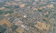
 Monument at the site of the first house built in Hooper in 1854 | |
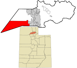
 Location in Weber County and the state of Utah | |
| Coordinates: 41°09′30″N 112°15′24″W / 41.15833°N 112.25667°W | |
| Country | United States |
| State | Utah |
| County | Weber |
| Settled | 1854 |
| Incorporated | November 30, 2000 |
| Founded by | William Henry Hooper |
| Area | |
• Total | 87.99 sq mi (227.90 km2) |
| • Land | 26.10 sq mi (67.60 km2) |
| • Water | 61.89 sq mi (160.30 km2) |
| Elevation | 4,196 ft (1,279 m) |
| Population (2020) | |
• Total | 9,087 |
| • Density | 100/sq mi (40/km2) |
| Time zone | UTC-7 (MST) |
| • Summer (DST) | UTC-6 (MDT) |
| ZIP code | 84315 |
| Area code(s) | 385, 801 |
| FIPS code | 49-36400[3] |
| GNIS feature ID | 2410790[2] |
| Website | www |

Hooper (/ˈhʊpər/ HUU-pər) is a city in Weber County, Utah, United States, first called Muskrat Springs and later Hooperville for Captain William Henry Hooper,[4] an early Utah delegate to Congress. The population was 9,087 at the 2020 census, up from the 2010 figure of 6,932. Prior to the city's incorporation on November 30, 2000, Hooper was an unincorporated census-designated place (CDP).
Hooper is part of the Ogden–Clearfield, Utah Metropolitan Statistical Area.
- ^ "2019 U.S. Gazetteer Files". United States Census Bureau. Retrieved August 7, 2020.
- ^ a b U.S. Geological Survey Geographic Names Information System: Hooper, Utah
- ^ "U.S. Census website". United States Census Bureau. Retrieved January 31, 2008.
- ^ The Utah Genealogical and Historical Magazine, Volumes 9-10. 1918. p. 188.