| Hopkins | |
|---|---|
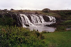
 Hopkins Falls, near Wangoom, in 1993 | |
| Etymology | In honour of Sir John Paul Hopkins.[1][2][3] |
| Location | |
| Country | Australia |
| State | Victoria |
| Region | Victorian Midlands (IBRA), Western District |
| Local government area | Moyne Shire, Warrnambool |
| Physical characteristics | |
| Source | |
| • location | near Ararat |
| • coordinates | 38°0′54″S 142°8′15″E / 38.01500°S 142.13750°E |
| • elevation | 338 m (1,109 ft) |
| Mouth | Southern Ocean |
• location | Warrnambool |
• coordinates | 38°24′9″S 142°30′29″E / 38.40250°S 142.50806°E |
• elevation | 0 m (0 ft) |
| Length | 271 km (168 mi) |
| Basin size | 8,843.9 km2 (3,414.6 sq mi)[4] |
| Discharge | |
| • location | Near mouth |
| • average | 62.6 m3/s (1,980 GL/a)[4] |
| Basin features | |
| River system | Glenelg Hopkins catchment |
| Tributaries | |
| • left | Jacksons Creek (Moyne Shire, Victoria), Salt Creek (Moyne Shire, Victoria), Stony Creek (Moyne Shire, Victoria), Mount Emu Creek, Brucknell Creek |
| • right | Back Creek (Moyne Shire, Victoria), Reedy Creek (Moyne Shire, Victoria), Bushy Creek (Moyne Shire, Victoria), Back Creek, Two (Moyne Shire, Victoria), Chirrup Creek, Grays Creek, Mustons Creek |
| Waterfall | Hopkins Falls |
| [5] | |
The Hopkins River, a perennial river of the Glenelg Hopkins catchment, is located in the Western District of Victoria, Australia.
- ^ Cite error: The named reference
mitchellwas invoked but never defined (see the help page). - ^ Cite error: The named reference
reedwas invoked but never defined (see the help page). - ^ Cite error: The named reference
birdwas invoked but never defined (see the help page). - ^ a b "East Coastal Watersheds".
- ^ "Map of Hopkins River, VIC". Bonzle Digital Atlas of Australia. Retrieved 20 June 2014.
