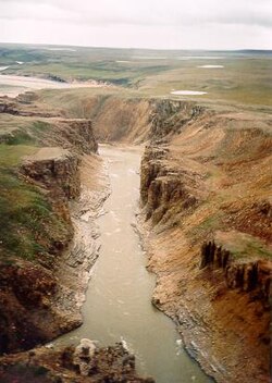
| Hornaday River | |
|---|---|
 | |
 | |
| Location | |
| Country | Canada |
| Physical characteristics | |
| Source | |
| • location | South of Bluenose Lake (Takipaq), Nunavut |
| Mouth | |
• location | Amundsen Gulf, Northwest Territories |
• coordinates | 69°19′50″N 123°47′41″W / 69.33056°N 123.79472°W |
• elevation | Sea level |
| Length | 190 km (120 mi) |
| Basin size | 13,120 km2 (5,070 sq mi)[1] |
| Discharge | |
| • average | 52.2 m3/s (1,840 cu ft/s)[1] |
Hornaday River (variants: Big River, Homaday River, Hornaaa River;[2] or Rivière La Roncière-le Noury[3]) is a waterway located above the Arctic Circle on the mainland of Northern Canada.
The upper reach of a river first discovered in 1868 was named Rivière La Roncière-le Noury in honour of Admiral Baron Adalbert Camille Marie Clément de La Roncière-Le Noury, commander of the Mediterranean Squadron, and president of the Société de Géographie. The lower reach of a river discovered in 1899 was named Hornaday after American zoologist William Temple Hornaday. Decades later, the Roncière and the Hornaday were ascertained to be the same river.
- ^ a b Ayles, G. Burton; Snow, Norman B. (January 2002). "Canadian Beaufort Sea 2000: The Environmental and Social Setting". Arctic. 55 (5, Supp. 1): 9. doi:10.14430/arctic731. ISSN 1923-1245. Retrieved 2015-05-29.
- ^ "Hornaday River (Nunavut and N.W.T.)". oclc.org. Retrieved 2009-03-06.[dead link]
- ^ Davis, Richard Clarke, ed. (1996). "Emile Petitot (1838 - 1916)". Lobsticks and Stone Cairns: Human Landmarks in the Arctic. Calgary, Canada: University of Calgary Press. pp. 153–154. ISBN 978-1-895176-88-9.