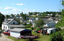
Hornepayne | |
|---|---|
| Township of Hornepayne | |
 | |
| Coordinates: 49°13′N 84°47′W / 49.217°N 84.783°W | |
| Country | Canada |
| Province | Ontario |
| District | Algoma |
| Established | 1915 |
| Incorporated | 1927 |
| Government | |
| • Type | Township |
| • Mayor | Cheryl T. Fort |
| • Federal riding | Algoma—Manitoulin—Kapuskasing |
| • Prov. riding | Algoma—Manitoulin |
| Area | |
| • Land | 203.04 km2 (78.39 sq mi) |
| Elevation | 332 m (1,089 ft) |
| Population (2021)[1] | |
| • Total | 968 |
| • Density | 4.8/km2 (12/sq mi) |
| Time zone | UTC-5 (EST) |
| • Summer (DST) | UTC-4 (EDT) |
| Postal Code | P0M |
| Area code | 807 |
| Highways | |
| Website | www |
Hornepayne is a township of 980 people (Canada 2016 Census) in the Algoma District of Ontario, Canada. The town was established in 1915 as Fitzback when the Canadian Northern Railway's transcontinental line was built through the area. It was renamed Hornepayne in 1920 after British financier Robert Horne-Payne.[3][4] The municipality was originally named Wicksteed Township after the geographic township in which it is located. It was renamed Hornepayne, after its primary community, in 1986.
- ^ a b "Hornepayne (Code 3557096) Census Profile". 2021 census. Government of Canada - Statistics Canada. Retrieved 2024-03-11.
- ^ White, James (1915). Altitudes in the Dominion of Canada (2nd ed.). Ottawa: Commission of Conservation. p. 240.
- ^ Roy, Patricia. "Robert Montgomery Horne-Payne". The Canadian Encyclopedia. Retrieved 3 October 2016.
- ^ Cite error: The named reference
douglaswas invoked but never defined (see the help page).

