| Horsham Victoria | |||||||||
|---|---|---|---|---|---|---|---|---|---|
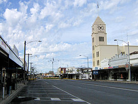
 Firebrace Street, Horsham's main street, in 2006 | |||||||||
 | |||||||||
| Coordinates | 36°43′S 142°12′E / 36.717°S 142.200°E | ||||||||
| Population | 20,429 (2021)[1] | ||||||||
| • Density | 854.8/km2 (2,214/sq mi) | ||||||||
| Postcode(s) | 3400 | ||||||||
| Elevation | 128 m (420 ft) | ||||||||
| Area | 23.9 km2 (9.2 sq mi) | ||||||||
| Location | |||||||||
| LGA(s) | Rural City of Horsham | ||||||||
| County | Borung | ||||||||
| State electorate(s) | Lowan | ||||||||
| Federal division(s) | Mallee | ||||||||
| |||||||||
Horsham (/ˈhɔːrʃəm/)[2] is a regional city in the Wimmera region of western Victoria, Australia. Located on a bend in the Wimmera River, Horsham is approximately 300 kilometres (190 mi) northwest of the state capital Melbourne. As of the 2021 census, Horsham had a population of 20,429.[1] It is the most populous city in Wimmera, and the main administrative centre for the Rural City of Horsham local government area. It is the eleventh largest city in Victoria after Melbourne, Geelong, Ballarat, Bendigo, Wodonga, Mildura, Shepparton, Warrnambool, Traralgon, and Wangaratta.
An early settler James Monckton Darlot named the settlement after the town of Horsham in his native England. It grew throughout the latter 19th and early 20th centuries as a centre of Western Victoria's wheat and wool industry, becoming the largest city in the Wimmera and Western Victoria by the early 1910s. Horsham was declared a city in 1949 and was named Australia's Tidiest Town in 2001[3] and Victoria's Tidiest Town in 2021.[4]
- ^ a b "2021 Horsham, Census All persons QuickStats | Australian Bureau of Statistics". www.abs.gov.au. Retrieved 28 June 2022.
- ^ Macquarie Dictionary, Fourth Edition (2005). Melbourne, The Macquarie Library Pty Ltd. ISBN 1-876429-14-3
- ^ HRCC. "Horsham Rural City Council". Archived from the original on 31 August 2007. Retrieved 30 October 2007.
- ^ Sylwia (17 November 2021). "Horsham named the Tidiest of them all". Keep Victoria Beautiful. Archived from the original on 9 August 2022. Retrieved 5 May 2022.
