| Hovenweep National Monument | |
|---|---|
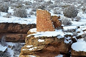
 Horseshoe Tower in the snow | |
| Location | Montezuma County, Colorado & San Juan County, Utah, USA |
| Nearest city | Bluff, Utah, Blanding, Utah |
| Coordinates | 37°23′2″N 109°4′38″W / 37.38389°N 109.07722°W |
| Area | 784 acres (317 ha)[1] |
| Created | March 2, 1923 |
| Visitors | 39,970 (in 2017)[2] |
| Governing body | U.S. National Park Service |
| Website | Hovenweep National Monument |
Hovenweep National Monument is located on land in southwestern Colorado and southeastern Utah, between Cortez, Colorado and Blanding, Utah on the Cajon Mesa of the Great Sage Plain. Shallow tributaries run through the wide and deep canyons into the San Juan River.[3]
Although Hovenweep National Monument is largely known for the six groups of Ancestral Puebloan villages and its kiva, there is evidence of occupation by hunter-gatherers from 8,000 to 6,000 B.C. until about AD 200. Later, a succession of early puebloan cultures settled in the area and remained until the 14th century.
Hovenweep became a National Monument in 1923 and is administered by the National Park Service. In July 2014, the International Dark-Sky Association designated Hovenweep an International Dark Sky Park.[4]
- ^ "Listing of acreage – December 31, 2011" (XLSX). Land Resource Division, National Park Service. Retrieved May 14, 2012. (National Park Service Acreage Reports)
- ^ "NPS Annual Recreation Visits Report". National Park Service. Retrieved April 9, 2018.
- ^ Hovenweep Visitor Guide, National Park Service. Retrieved 9-20-2011.
- ^ "Hovenweep National Monument Named World's Newest International Dark Sky Park" (Press release). Tucson: SBWire. July 1, 2014. Retrieved July 14, 2014.

