Howard County | |
|---|---|
 The Howard County Courthouse in Fayette | |
| Nickname: Mother of Counties | |
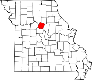
 Location within the U.S. state of Missouri | |
 Missouri's location within the U.S. | |
| Coordinates: 39°08′N 92°42′W / 39.14°N 92.7°W | |
| Country | |
| State | |
| Founded | January 23, 1816 |
| Named for | Benjamin Howard |
| Seat | Fayette |
| Largest city | Fayette |
| Area | |
• Total | 472 sq mi (1,220 km2) |
| • Land | 464 sq mi (1,200 km2) |
| • Water | 7.7 sq mi (20 km2) 1.6% |
| Population (2020) | |
• Total | 10,151 |
| • Density | 22/sq mi (8.3/km2) |
| Time zone | UTC−6 (Central) |
| • Summer (DST) | UTC−5 (CDT) |
| Congressional district | 4th |
Howard County is located in the U.S. state of Missouri, with its southern border formed by the Missouri River. As of the 2020 census, the population was 10,151.[1] Its county seat is Fayette.[2]
The county was organized January 23, 1816, a year after the end of the War of 1812 (1812-1815), and named for Benjamin Howard (1760-1814, served 1809-1813), only two years after his death. He was an officer in the United States Army, and was appointed by fourth President James Madison as the first Governor of the newky reorganized Missouri Territory (1812-1821), with its new capital city in nearby St. Louis, bustling driver port city on the Mississippi River and near the confluence with the Ohio River flowing from the northeast and the closer Missouri River streaming rom the northwest. Governor Howard oversaw the new federal territory when it was separated from the previous larger Louisiana Territory of 1804-1812, which encompassed the huge uncharted recent Louisiana Purchase of 1803, west of the Mississippi towards the distant Rocky Mountains, when sold to the United States by the Emperor Napoleon I / Napoleon Bonaparte of France (the First French Empire) for a paltry $15 million dollars. The subsequent Missouri Territory was formed nine years later since the land bargain, and the previous short-lived Louisiana Territory's southern portion along the lower Mississippi River and with the former territorial capital at the major prosperous river port city of New Orleans near the Gulf of Mexico coast, was approved by the United States Congress and President Madison to be separated and formed to be admitted to the federal Union as the new 18th State of Louisiana in 1812.
This was just prior to the outbreak of the War of 1812 (1812-1815), renewed conflict with the British (and former English) again of the united Kingdom. Territorial Governor Howard was instrumental and involved in this history, although he died in the midst of the war's last year, and before the British Army and Royal Navy attack in the famous crucial Battle of New Orleans in January 1815, the last battle of the warm a month after a peace treaty was signed in December 1814, in far-off Europe.[3] Settled originally by migrants from the Upper South, it is part of the region historically known as Little Dixie. It is part of the Columbia, Missouri, metropolitan area.
- ^ "Explore Census Data". data.census.gov. Retrieved January 5, 2022.
- ^ "Find a County". National Association of Counties. Archived from the original on May 31, 2011. Retrieved June 7, 2011.
- ^ Eaton, David Wolfe (1916). How Missouri Counties, Towns and Streams Were Named. The State Historical Society of Missouri. pp. 174.