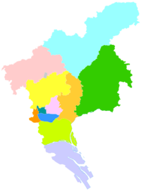
Huangpu
黄埔区 Whampoa; Whangpoa | |
|---|---|
 Dasha Subdistrict | |
 | |
 Huangpu in Guangzhou | |
| Coordinates: 23°6′33.904″N 113°27′15.11″E / 23.10941778°N 113.4541972°E | |
| Country | People's Republic of China |
| Province | Guangdong |
| Sub-provincial city | Guangzhou |
| Area | |
• Total | 484.17 km2 (186.94 sq mi) |
| Population (2020[1]) | |
• Total | 1,264,447 |
| • Density | 2,600/km2 (6,800/sq mi) |
| Time zone | UTC+8 (China Standard) |
| Postal code | 510700 |
| Area code | 020 |
| Website | www |
| Huangpu, Guangzhou | |||||||||||||||
|---|---|---|---|---|---|---|---|---|---|---|---|---|---|---|---|
| Simplified Chinese | 黄埔区 | ||||||||||||||
| Traditional Chinese | 黃埔區 | ||||||||||||||
| Guangdong Romanization | Wong4-bou3 Kêu1 | ||||||||||||||
| Hanyu Pinyin | Huángpǔ Qū | ||||||||||||||
| Literal meaning | Yellow Bank District | ||||||||||||||
| |||||||||||||||
| Alternative Chinese name | |||||||||||||||
| Simplified Chinese | 黄埔 | ||||||||||||||
| Traditional Chinese | 黃埔 | ||||||||||||||
| Guangdong Romanization | Wong4-bou3 | ||||||||||||||
| Hanyu Pinyin | Huángpǔ | ||||||||||||||
| |||||||||||||||
Huangpu, alternately romanized as Whampoa, is one of 11 urban districts of the prefecture-level city of Guangzhou, the capital of Guangdong Province, China. Despite its name, it does not include Huangpu Island (now Pazhou) or its famous anchorage. Huangpu absorbed Guangzhou's former Luogang District in 2014. The district has been awarded the status of "Happiest District of China" in 2020.[2]
- ^ "Guangzhou: Subdivision". Retrieved 25 March 2024.
- ^ Cite error: The named reference
:4was invoked but never defined (see the help page).