| Hudson River | |
|---|---|
 | |
 | |
| Location | |
| Country | United States |
| State | New York, New Jersey |
| City | See Populated places on the Hudson River |
| Physical characteristics | |
| Source | Henderson Lake (New York) (See Sources) |
| • location | Adirondack Mountains, New York, United States |
| • coordinates | 44°05′29″N 74°03′33″W / 44.09139°N 74.05917°W[3] |
| • elevation | 1,770 ft (540 m)[4] |
| Mouth | Atlantic Ocean, New York Harbor |
• location | Jersey City, New Jersey and Lower Manhattan, New York, United States |
• coordinates | 40°41′48″N 74°01′42″W / 40.69667°N 74.02833°W[3] |
• elevation | 0 ft (0 m) |
| Length | 315 mi (507 km) |
| Basin size | 14,000 sq mi (36,000 km2) |
| Depth | |
| • average | 30 ft (9.1 m) (extent south of Troy) |
| • maximum | 202 ft (62 m) |
| Discharge | |
| • location | Lower New York Bay[1] |
| • average | 21,900 cu ft/s (620 m3/s) |
| Discharge | |
| • location | Green Island[2] |
| • average | 17,400 cu ft/s (490 m3/s) |
| • minimum | 882 cu ft/s (25.0 m3/s) |
| • maximum | 215,000 cu ft/s (6,100 m3/s) |
| Basin features | |
| Tributaries | |
| • left | Boreas River, Schroon River, Batten Kill, Hoosic River, Kinderhook Creek, Roeliff Jansen Kill, Wappinger Creek, Croton River, Sing Sing Kill, Fishkill |
| • right | Cedar River, Indian River, Sacandaga River, Mohawk River, Normans Kill, Catskill Creek, Esopus Creek, Rondout Creek, Wallkill River |
| Waterfalls | Ord Falls, Spier Falls, Glens Falls, Bakers Falls |

| |
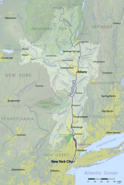
 The Hudson River Watershed, including the Hudson and Mohawk rivers | |
The Hudson River is a 315-mile (507 km) river that flows from north to south primarily through eastern New York, United States. It originates in the Adirondack Mountains of upstate New York at Henderson Lake in the town of Newcomb, and flows southward through the Hudson Valley to the New York Harbor between New York City and Jersey City, eventually draining into the Atlantic Ocean at Upper New York Bay. The river serves as a physical boundary between the states of New Jersey and New York at its southern end. Farther north, it marks local boundaries between several New York counties. The lower half of the river is a tidal estuary, deeper than the body of water into which it flows, occupying the Hudson Fjord, an inlet that formed during the most recent period of North American glaciation, estimated at 26,000 to 13,300 years ago. Even as far north as the city of Troy, the flow of the river changes direction with the tides.
The Hudson River runs through the Munsee, Lenape, Mohican, Mohawk, and Haudenosaunee homelands. Prior to European exploration, the river was known as the Mahicannittuk by the Mohicans, Ka'nón:no by the Mohawks, and Muhheakantuck by the Lenape. The river was subsequently named after Henry Hudson, an Englishman sailing for the Dutch East India Company who explored it in 1609, and after whom Hudson Bay in Canada is also named. It had previously been observed by Italian explorer Giovanni da Verrazzano sailing for King Francis I of France in 1524, as he became the first European known to have entered the Upper New York Bay, but he considered the river to be an estuary. The Dutch called the river the North River, and they called the present-day Delaware River the South River, which formed the spine of the Dutch colony of New Netherland. Settlements of the colony clustered around the Hudson, and its strategic importance as the gateway to the American interior led to years of competition between the English and the Dutch over control of the river and colony.
During the 18th century, the river valley and its inhabitants were the subject and inspiration of Washington Irving, the first internationally acclaimed American author. In the nineteenth century, the area inspired the Hudson River School of landscape painting, an American pastoral style, as well as the concepts of environmentalism and wilderness. The Hudson River was also the eastern outlet for the Erie Canal, which, when completed in 1825, became an important transportation artery for the early 19th century United States.
Pollution in the Hudson River increased in the 20th century, more acutely by mid-century, particularly with industrial contamination from polychlorinated biphenyls, also known by their acronym PCBs. Pollution control regulations, enforcement actions and restoration projects initiated in the latter 20th century have begun to improve water quality, and restoration work has continued in the 21st century.[5][6]
| Hamilton |
| Essex |
| Warren |
| Washington |
| Saratoga |
| Albany |
| Rensselaer |
| Greene |
| Columbia |
| Ulster |
| Dutchess |
| Putnam |
| Orange |
| Rockland |
| Westchester |
| Bronx |
| Bergen, NJ |
| Hudson, NJ |
| New York |
| Source:[7] |
- ^ Cite error: The named reference
Dischargewas invoked but never defined (see the help page). - ^ Cite error: The named reference
Green Island Dischargewas invoked but never defined (see the help page). - ^ a b "Hudson River". Geographic Names Information System. United States Geological Survey, United States Department of the Interior.
- ^ "Santanoni Peak, NY" 1:25,000 Topographic Quadrangle, 1999, USGS
- ^ Hudson River Estuary Program; NY-NJ Harbor & Estuary Program; NEIWPCC (October 2020). The State of the Hudson 2020 (PDF) (Report). New York State Department of Environmental Conservation (NYSDEC).
- ^ "Hudson River Cleanup". Hudson River PCBs Superfund Site. New York: US Environmental Protection Agency (EPA). October 5, 2021.
- ^ Cite error: The named reference
GNISwas invoked but never defined (see the help page).