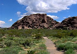
Hueco Tanks | |
 East Mountain at Hueco Tanks | |
| Nearest city | El Paso, Texas |
|---|---|
| Coordinates | 31°55′13″N 106°02′19″W / 31.92028°N 106.03861°W |
| Area | 860 acres (350 ha) |
| NRHP reference No. | 71000930[1] |
| Significant dates | |
| Prehistoric | 1000-1499 AD |
| Historic Aboriginal | 1500-1824 |
| Added to NRHP | July 14, 1971 |
| Designated NHL | January 13, 2021 |
| Designated TSHS | June 12, 1969 |
Hueco Tanks is an area of low mountains and historic site in El Paso County, Texas, in the United States. It is located in a high-altitude desert basin between the Franklin Mountains to the west and the Hueco Mountains to the east. Hueco is a Spanish word meaning hollows and refers to the many water-holding depressions in the boulders and rock faces throughout the region. Due to the unique concentration of historic artifacts, plants and wildlife, the site is under protection of Texas law; it is a crime to remove, alter, or destroy them.[2]
The historic site is located approximately 32 miles (51 km) northeast of central El Paso, Texas, accessible via El Paso's Montana Avenue (U.S. Route 62/U.S. Route 180), by turning at RM 2775. The park consists of three syenite (a weak form of granite) mountains; it is 860 acres (350 ha) in area[3] and is popular for recreation such as birdwatching and bouldering. It is culturally and spiritually significant to many Native Americans. This significance is partially manifested in the pictographs (rock paintings) that can be found throughout the region, many of which are thousands of years old.[4]
- ^ "National Register Information System". National Register of Historic Places. National Park Service. July 9, 2010.
- ^ Sutherland 1996 p.25
- ^ Rentería, Ramón (24 May 2011). "Ancient desert oasis - Hueco Tanks a monument to native cultures". Las Cruces Sun-News.
- ^ Mulvihill, K. "On Rock Walls, Painted Prayers to Rain Gods", The New York Times. September 19, 2008. Retrieved 9/19/08.

