This article needs additional citations for verification. (June 2015) |
Hulu Selangor District | |
|---|---|
| Daerah Hulu Selangor | |
| Other transcription(s) | |
| • Jawi | دايره هولو سلاڠور |
| • Chinese | 乌鲁雪兰莪县 |
| • Tamil | உலு சிலாங்கூர் |
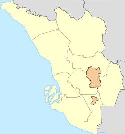
 Hulu Selangor shown within Selangor state | |
 | |
Location of Hulu Selangor District in Malaysia | |
| Coordinates: 3°35′N 101°35′E / 3.583°N 101.583°E | |
| Country | |
| State | |
| Granted Municipal Status | 21 October 2021 |
| Seat | Kuala Kubu Bharu |
| Local area government(s) | Hulu Selangor Municipal Council |
| Area | |
• Total | 1,756.30 km2 (678.11 sq mi) |
| Population (2020)[2] | |
• Total | 239,978 |
| • Density | 140/km2 (350/sq mi) |
| Time zone | UTC+8 (MST) |
| • Summer (DST) | UTC+8 (Not observed) |
| Postcode | 44xxx, 482xx |
| Calling code | +6-03 |
| Vehicle registration plates | B |

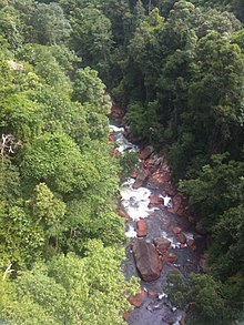
Hulu Selangor is a district in Selangor, Malaysia. It contains the towns of Serendah, Batang Kali and Kuala Kubu Bharu. Its principal town is Kuala Kubu Bharu. The district is located in the northeastern part of Selangor and borders the state of Perak to the north, Pahang to the east, Sabak Bernam district to the northwest, Kuala Selangor district to its southwest and Gombak district to the south. Selangor River sources from this area, hence giving the district's name.
- ^ "Portal Rasmi PDT Hulu Selangor Guna Tanah". www2.selangor.gov.my. Archived from the original on 2019-06-22. Retrieved 2017-12-24.
- ^ "Population Distribution and Basic Demographic Characteristics, 2010" (PDF). Department of Statistics, Malaysia. Archived from the original (PDF) on 22 May 2014. Retrieved 19 April 2012.


