Hundested | |
|---|---|
Town | |
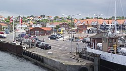
 The Rørvig ferry in the harbour | |
| Coordinates: 55°58′N 11°51′E / 55.967°N 11.850°E | |
| Country | |
| Region | Capital Region |
| Municipality | Halsnæs |
| Area | |
| • Urban | 7.6 km2 (2.9 sq mi) |
| Population (2024) | |
| • Urban | 8,538 |
| • Urban density | 1,100/km2 (2,900/sq mi) |
| • Gender [1] | 4,221 males and 4,317 females |
| Time zone | UTC+1 (CET) |
| • Summer (DST) | UTC+2 (CEST) |
| Postal code | DK-3390 Hundested |
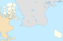
Hundested is a town with a population of 8,538 (1 January 2024)[2] and a former municipality (Danish, kommune) in Region Hovedstaden in the northern part of the island of Zealand (Sjælland) in eastern Denmark.
The former municipality is surrounded by water on three side: to the north is the Kattegat, to the west is the channel leading into the Isefjord, and to the south is Roskilde Fjord and the channel leading into it from the Isefjord.
The area is characterized by sand and dunes, especially on its northern side facing the Kattegat, but also found in the central areas and in the south. Kikhavn on the northern side of the peninsula, not far to the east of the town of Hundested, is the oldest fishing village in the area.
- ^ BY1: Population 1. January by urban areas, age and sex The Mobile Statbank from Statistics Denmark
- ^ BY3: Population 1. January by urban areas, area and population density The Mobile Statbank from Statistics Denmark

