Huntsville International Airport Carl T. Jones Field | |||||||||||||||
|---|---|---|---|---|---|---|---|---|---|---|---|---|---|---|---|
 | |||||||||||||||
 NAIP 2006 orthophoto | |||||||||||||||
| Summary | |||||||||||||||
| Airport type | Public | ||||||||||||||
| Owner | Huntsville / Madison County Airport Authority | ||||||||||||||
| Serves | Huntsville, Alabama | ||||||||||||||
| Elevation AMSL | 629 ft / 192 m | ||||||||||||||
| Coordinates | 34°38′14″N 86°46′30″W / 34.63722°N 86.77500°W | ||||||||||||||
| Website | flyhuntsville | ||||||||||||||
| Maps | |||||||||||||||
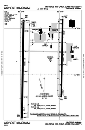
 FAA airport diagram | |||||||||||||||
 | |||||||||||||||
| Runways | |||||||||||||||
| |||||||||||||||
| Statistics (2023) | |||||||||||||||
| |||||||||||||||


Huntsville International Airport (IATA: HSV[3], ICAO: KHSV, FAA LID: HSV) (Carl T. Jones Field) is a public airport and spaceport ten miles southwest of downtown Huntsville, in Madison County, Alabama, United States. The FAA has designated the Huntsville International Airport as a Re-entry site for the Dream Chaser, a spaceplane operated by Sierra Space to make reentries from Low Earth Orbit (LEO).
The airport is part of the Port of Huntsville (along with the International Intermodal Center and Jetplex Industrial Park), and serves the Huntsville-Decatur Combined Statistical Area. Opened in October 1967 as the Huntsville Jetport, it was the third airport for Huntsville.[4][5] The airport has 12 gates with restrooms, shops, restaurants, phones and murals depicting aviation and space exploration scenes. The airport also has on a 3-star hotel on the premises.[6] The Four Points by Sheraton is located above the ticketing area and lobby, (adjacent to the terminal is a parking garage and to opposite sides are the control tower and a golf course).
The airport's west runway, at 12,600 ft (3,800 m), is the second longest commercial runway in the southeastern United States, being 400 ft (120 m) shorter than the longest runway at Miami International Airport. Huntsville is frequently used as a diversion airport from larger hubs in the Southeast, such as Atlanta, due to its long runways and sophisticated snow removal and de-icing equipment.[7]
The airport's "Fly Huntsville" marketing campaign encourages passengers to depart from Huntsville instead of driving to Birmingham or Nashville.[8] An August 2009 report by the Bureau of Transportation Statistics for the first quarter of 2009 revealed that Huntsville passengers paid, on average, was the highest airfares in the United States.[9] However, the airport reported that commercial airline passenger traffic increased 2.3% in January 2010 over the previous year.[10]
The National Plan of Integrated Airport Systems for 2011–2015 called it a primary commercial service airport.[11] Federal Aviation Administration records say the airport had 612,690 passenger boardings (enplanements) in calendar year 2008,[12] 572,767 in 2009 and 606,127 in 2010.[13]
- ^ FAA Airport Form 5010 for HSV PDF. Federal Aviation Administration. effective January 25, 2024.
- ^ "HSV Airport Statistics for 2023". flyhuntsville.com. Retrieved February 12, 2024.
- ^ "IATA Airport Code Search (HSV: Huntsville Intl)". International Air Transport Association. Retrieved July 28, 2013.
- ^ "Huntsville's New Jetport Will Be First of Its Kind". The Tuscaloosa News. March 24, 1966. p. 5. Retrieved March 18, 2012.
- ^ Freeman, Paul. "Alabama: Huntsville area". Abandoned & Little-Known Airfields. Retrieved December 25, 2011.
- ^ "Four Points by Sheraton Huntsville Airport | Marriott Bonvoy". www.marriott.com. Retrieved 2023-12-31.
- ^ "Huntsville International Airport is prepared for diversions caused by winter weather". WHNT.com. 2017-01-08. Retrieved 2018-08-01.
- ^ Baskas, Harriet (March 12, 2008). "Better branding through music: Original airport theme songs". USA Today.
- ^ "Flights from Huntsville ranked most expensive". WAAY-TV. Associated Press. August 4, 2009. Archived from the original on July 17, 2011.
- ^ Clines, Keith (February 10, 2010). "Passenger traffic at airport starts to climb". The Huntsville Times. Archived from the original on June 8, 2011.
- ^ "2011–2015 NPIAS Report, Appendix A" (PDF). National Plan of Integrated Airport Systems. Federal Aviation Administration. October 4, 2010. Archived from the original (PDF, 2.03 MB) on September 27, 2012.
- ^ "Enplanements for CY 2008" (PDF, 1.0 MB). 2008 Passenger Boarding and All-Cargo Data. Federal Aviation Administration. December 18, 2009.
- ^ "Enplanements for CY 2010" (PDF, 189 KB). 2010 CY 2010 Passenger Boarding and All-Cargo Data. Federal Aviation Administration. October 4, 2011.