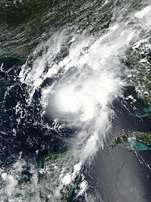
 Hurricane Marco approaching Louisiana at peak intensity on August 23 | |
| Meteorological history | |
|---|---|
| Formed | August 20, 2020 |
| Remnant low | August 25, 2020 |
| Dissipated | August 26, 2020 |
| Category 1 hurricane | |
| 1-minute sustained (SSHWS/NWS) | |
| Highest winds | 75 mph (120 km/h) |
| Lowest pressure | 991 mbar (hPa); 29.26 inHg |
| Overall effects | |
| Fatalities | None |
| Damage | >$35 million (2020 USD) |
| Areas affected | Central America, western Caribbean, Yucatán Peninsula, Gulf Coast of the United States |
| IBTrACS / [1] | |
Part of the 2020 Atlantic hurricane season | |
Hurricane Marco was the first of two tropical cyclones to threaten the Gulf Coast of the United States within a three-day period. The thirteenth named storm and third hurricane of the record-breaking 2020 Atlantic hurricane season, Marco developed from a fast-moving tropical wave west of the Windward Islands and south of Jamaica on August 20. The fast motion of the wave inhibited intensification initially, but as the wave slowed down and entered a more favorable environment, the system developed into a tropical depression, which in turn rapidly intensified into a strong tropical storm. Due to strong wind shear, Marco's intensification temporarily halted. However, after entering the warm waters of the Gulf of Mexico on August 23, Marco briefly intensified into a hurricane, only to quickly weaken later that evening due to another rapid increase in wind shear. Marco subsequently weakened to a tropical depression before degenerating into a remnant low early the next morning. Marco's remnants subsequently dissipated on August 26.
Heavy rains across the Yucatán Peninsula caused river rises and flooding throughout the region. One person was indirectly killed in Tapachula, Mexico, due to the storm, although this was not included in the official death toll. Impacts in the United States were generally minor, as the storm was considerably weakened by the time it impacted the Gulf Coast. Marco did not make landfall, turning parallel to the U.S. coastline, unlike subsequent Hurricane Laura.