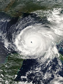
 Rita near its record peak intensity on September 21 | |
| Meteorological history | |
|---|---|
| Formed | September 18, 2005 |
| Dissipated | September 26, 2005 |
| Category 5 major hurricane | |
| 1-minute sustained (SSHWS/NWS) | |
| Highest winds | 180 mph (285 km/h) |
| Lowest pressure | 895 mbar (hPa); 26.43 inHg (Lowest recorded in the Gulf of Mexico) |
| Overall effects | |
| Fatalities | 120 |
| Damage | $18.5 billion (2005 USD) |
| Areas affected | Hispaniola, Turks and Caicos Islands, Bahamas, Cuba, Florida, Georgia, Mississippi, Louisiana, Texas, Oklahoma, Arkansas, Missouri, Tennessee, Kentucky, Illinois, Great Lakes region |
| IBTrACS | |
Part of the 2005 Atlantic hurricane season | |
Hurricane Rita was the most intense tropical cyclone on record in the Gulf of Mexico and the fourth-most intense Atlantic hurricane ever recorded. Part of the record-breaking 2005 Atlantic hurricane season, which included three of the top ten most intense Atlantic hurricanes in terms of barometric pressure ever recorded (along with Wilma and Katrina), Rita was the seventeenth named storm, tenth hurricane, and fifth major hurricane of the 2005 season.[nb 1] It was also the earliest-forming 17th named storm in the Atlantic until Tropical Storm Rene in 2020. Rita formed near The Bahamas from a tropical wave on September 18, 2005, that originally developed off the coast of West Africa. It moved westward, and after passing through the Florida Straits, Rita entered an environment of abnormally warm waters. Moving west-northwest, it rapidly intensified to reach peak winds of 180 mph (285 km/h),[nb 2] achieving Category 5 status on September 21. However, it weakened to a Category 3 hurricane before making landfall in Johnson's Bayou, Louisiana, between Sabine Pass, Texas and Holly Beach, Louisiana, with winds of 115 mph (185 km/h). Rapidly weakening over land, Rita degenerated into a large low-pressure area over the lower Mississippi Valley by September 26.
In Louisiana, Rita's storm surge inundated low-lying communities along the entire coast, worsening effects caused by Hurricane Katrina less than a month prior, such as topping the hurriedly-repaired Katrina-damaged levees at New Orleans. Parishes in Southwest Louisiana and counties in Southeast Texas where Rita made landfall suffered from severe to catastrophic flooding and wind damage. According to an October 25, 2005, Disaster Center report, 4,526 single-family dwellings were destroyed in Orange and Jefferson counties located in Southeast Texas. Major damage was sustained by 14,256 additional single-family dwellings, and another 26,211 single-family dwellings received minor damage. Mobile homes and apartments also sustained significant damage or total destruction.[2] In all, nine Texas counties and five Louisiana Parishes were declared disaster areas after the storm. Electric service was disrupted in some areas of both Texas and Louisiana for several weeks. Texas reported the most deaths from the hurricane, where 113 deaths were reported, 107 of which were associated with the evacuation of the Houston metropolitan area.
Moderate to severe damage was reported across the lower Mississippi Valley. Rainfall from the storm and its associated remnants extended from Louisiana to Michigan. Rainfall peaked at 16.00 in (406 mm) in Central Louisiana. Several tornadoes were also associated with the hurricane and its subsequent remnants. Throughout the path of Rita, damage totaled about $18.5 billion (2005 USD).[3] As many as 120 deaths in four U.S. states were directly related to the hurricane.
- ^ "Saffir-Simpson Hurricane Wind Scale". National Hurricane Center. Archived from the original on June 20, 2020. Retrieved June 22, 2020.
- ^ "The Disaster Center's Tropical Storm - Hurricane Rita Page". disastercenter.com. October 25, 2005. Archived from the original on April 29, 2020. Retrieved January 2, 2015.
- ^ Costliest U.S. tropical cyclones tables updated (PDF) (Report). National Hurricane Center. January 26, 2018. Archived (PDF) from the original on January 27, 2018. Retrieved January 28, 2018.
Cite error: There are <ref group=nb> tags on this page, but the references will not show without a {{reflist|group=nb}} template (see the help page).