| Te Awa Kairangi / Hutt River Te Wai o Orutu | |
|---|---|
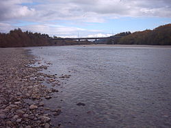
 The Hutt River looking downstream | |
 | |
| Native name | Te Awa Kairangi (Māori) |
| Location | |
| Country | New Zealand |
| Physical characteristics | |
| Source | |
| • location | Tararua Ranges |
| Mouth | |
• location | Wellington Harbour |
• elevation | 0 m (0 ft) |
| Length | 56 km (35 mi) |
| Basin size | 655 km2 (253 sq mi) |
The Hutt River (Māori: Te Awa Kairangi, Te Wai o Orutu or Heretaunga; officially Te Awa Kairangi / Hutt River) flows through the southern North Island of New Zealand. It flows south-west from the southern Tararua Range for 56 kilometres (35 mi), forming a number of fertile floodplains, including Kaitoke, central Upper Hutt and Lower Hutt.[1]
The Hutt River Trail, a regional park administered by Wellington Regional Council, runs alongside the eastern side of the river.[1]
- ^ a b "Hutt River Trail". gw.govt.nz. Wellington Regional Council.