| Hwange National Park | |
|---|---|
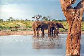
 African bush elephants in a waterhole of the park | |
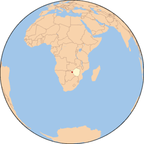
 The park (in red) on a map of Africa with Zimbabwe highlighted | |
| Location | Matabeleland North, Zimbabwe |
| Nearest city | Hwange |
| Coordinates | 18°44′06″S 26°57′18″E / 18.735°S 26.955°E |
| Area | 14,651 km2 (5,657 sq mi)[1] |
| Established | 1928 as a Game Reserve[2] (1961 as a National Park)[1] |
| Governing body | Zimbabwe Parks and Wildlife Management Authority |
Hwange National Park (formerly Wankie Game Reserve) is the largest natural reserve in Zimbabwe. It is around 14,600 sq km in area. It lies in the northwest of the country, just off the main road between Bulawayo and Victoria Falls. The nearest town is Dete. Histories of the region's pre-colonial days and its development as a game reserve and National Park are available online [3][4][5]
- ^ a b National Parks and Nature Reserves of Zimbabwe, World Institute for Conservation and Environment Archived 16 April 2012 at the Wayback Machine.
- ^ G. Child; B. Reese (1977). Wankie National Park. National Parks and Wildlife Management of Rhodesia.
- ^ Haynes, G.; Klimowicz, J. (2020). Hwange National Park's Historic and Pre-Historic Places (Report). Unpublished. doi:10.13140/RG.2.2.31002.06086.
- ^ Haynes, G. (2020). "The Forest with a Desert Heart". Hwange National Park: The Forest with a Desert Heart (Report). doi:10.13140/RG.2.2.19784.55043.
- ^ Haynes, G. (2020). "Colonial Days; Ted Davison Makes A Great Game Reserve". Hwange National Park: The Forest with a Desert Heart (Report). doi:10.13140/RG.2.2.23441.45922.