Hyannis, Nebraska | |
|---|---|
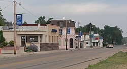
 Downtown Hyannis, looking southwest. Nebraska Highway 2/61 is in the foreground | |
 Location of Hyannis, Nebraska | |
| Coordinates: 42°00′02″N 101°45′44″W / 42.00056°N 101.76222°W | |
| Country | United States |
| State | Nebraska |
| County | Grant |
| Area | |
| • Total | 0.52 sq mi (1.35 km2) |
| • Land | 0.52 sq mi (1.35 km2) |
| • Water | 0.00 sq mi (0.00 km2) |
| Elevation | 3,757 ft (1,145 m) |
| Population (2020) | |
| • Total | 165 |
| • Density | 316.70/sq mi (122.31/km2) |
| Time zone | UTC-7 (Mountain (MST)) |
| • Summer (DST) | UTC-6 (MDT) |
| ZIP code | 69350 |
| Area code | 308 |
| FIPS code | 31-23655[3] |
| GNIS feature ID | 2398566[2] |
Hyannis is a village in Grant County, Nebraska, United States. The population was 165 at the time of the 2020 census. It is the county seat of Grant County.[4] It is centrally located in the extensive, unique, and remote region of grasslands known as the Sandhills of Nebraska at the intersection of two Nebraska State Highways: NSH 61 which runs north and south, and NSH 2, which runs east and west.
- ^ "ArcGIS REST Services Directory". United States Census Bureau. Retrieved September 18, 2022.
- ^ a b U.S. Geological Survey Geographic Names Information System: Hyannis, Nebraska
- ^ "U.S. Census website". United States Census Bureau. Retrieved January 31, 2008.
- ^ "Find a County". National Association of Counties. Archived from the original on May 31, 2011. Retrieved June 7, 2011.