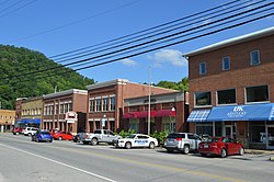
Hyden, Kentucky | |
|---|---|
 Main Street | |
| Nickname: Redbud Capital of the World | |
 Location of Hyden, Kentucky | |
| Coordinates: 37°9′48″N 83°22′30″W / 37.16333°N 83.37500°W | |
| Country | United States |
| State | Kentucky |
| County | Leslie |
| Incorporated | March 18, 1882 |
| Government | |
| • Type | City Commission |
| • Mayor | Carol Lewis Joseph |
| Area | |
• Total | 1.34 sq mi (3.46 km2) |
| • Land | 1.30 sq mi (3.36 km2) |
| • Water | 0.04 sq mi (0.10 km2) |
| Elevation | 922 ft (281 m) |
| Population (2020) | |
• Total | 303 |
| • Density | 233.80/sq mi (90.27/km2) |
| Time zone | UTC-5 (Eastern (EST)) |
| • Summer (DST) | UTC-4 (EDT) |
| ZIP codes | 41749, 41762 |
| Area code | 606 |
| FIPS code | 21-38908 |
| GNIS feature ID | 0512880 |
| Website | www |
Hyden is a home rule-class city in and the county seat of Leslie County, Kentucky, United States.[2] The population was 365 at the 2010 census.[3] It is located at the junction of U.S. Route 421 and Kentucky Route 80, along the Middle Fork of the Kentucky River.
- ^ "2020 U.S. Gazetteer Files". United States Census Bureau. Retrieved March 18, 2022.
- ^ "Find a County". National Association of Counties. Archived from the original on May 31, 2011. Retrieved June 7, 2011.
- ^ "Total Population: 2010 Census DEC Summary File 1 (P1), Hyden city, Kentucky". data.census.gov. U.S. Census Bureau. Retrieved February 10, 2020.