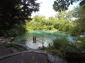
| Ichetucknee Springs State Park | |
|---|---|
IUCN category V (protected landscape/seascape) | |
 Headspring | |
| Location | Columbia, Florida, USA |
| Nearest city | Fort White, Florida |
| Coordinates | 29°58′2.47″N 82°46′33.82″W / 29.9673528°N 82.7760611°W |
| Area | 2,241 acres (9.07 km2) |
| Governing body | Florida Department of Environmental Protection |
| Website | https://www.floridastateparks.org/parks-and-trails/ichetucknee-springs-state-park?origin=serp_auto |
| Designated | October 1971 |
Ichetucknee Springs State Park is a 2,241-acre (9.07 km2) Florida State Park and National Natural Landmark located 4 miles (6 km) northwest of Fort White off State Road 47 and State Road 238. It centers around the 6-mile-long (10 km) Ichetucknee River, which flows through shaded hammocks and wetlands into the Santa Fe River. The park contains hardwood hammock and limestone outcrops. Like many rivers in this part of North Florida, the Ichetucknee is fed by natural springs which boil up (in various holes) from the aquifer. The state of Florida purchased the property in 1970 from the Loncala Phosphate Corporation for $1,850,000.

