This article needs additional citations for verification. (February 2015) |
| Iditarod Trail | |
|---|---|
 Robert Sorlie and team near Nome | |
| Length | 1,600 mi (2,600 km) |
| Location | Alaska |
| Established | 1973 |
| Designation | National Historic Trail |
| Trailheads | Start: 61°44′42″N 150°03′04″W / 61.7450°N 150.0511°W Finish: 64°29′53″N 165°24′40″W / 64.4981°N 165.4112°W |
| Use | Sled dog racing |
| Maintained by | Volunteers |
| Website | https://www.iditarod.com |

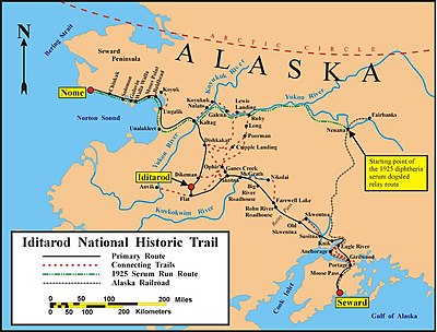
The Iditarod Trail, also known historically as the Seward-to-Nome Trail, is a thousand-plus mile (1,600 km) historic and contemporary trail system in the US state of Alaska. The trail began as a composite of trails established by Alaskan native peoples. Its route crossed several mountain ranges and valleys and passed through numerous historical settlements en route from Seward to Nome. The discovery of gold around Nome brought thousands of people over this route beginning in 1908. Roadhouses for people and dog barns sprang up every 20 or so miles. By 1918 World War I and the lack of 'gold fever' resulted in far less travel. The trail might have been forgotten except for the 1925 diphtheria outbreak in Nome. In one of the final great feats of dog sleds, twenty drivers and teams carried the life-saving serum 674 miles (1,085 km) in 127 hours. Today, the Iditarod Trail Sled Dog Race serves to commemorate the part the trail and its dog sleds played in the development of Alaska, and the route and a series of connecting trails have been designated Iditarod National Historic Trail.