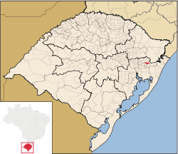
Município de Igrejinha | |
|---|---|
 Location in Rio Grande do Sul, Brazil | |
| Coordinates: 29°34′26″S 50°47′24″W / 29.57389°S 50.79000°W | |
| Country | Brazil |
| Region | South |
| State | Rio Grande do Sul |
| Emanciped | 1964-06-01 |
| Government | |
| • Mayor | Joel Leandro Wilhelm (PP) |
| Area | |
• Total | 136.816 km2 (52.825 sq mi) |
| Elevation | 18 m (59 ft) |
| Population | |
• Total | 37,340 |
| • Density | 229.4/km2 (594/sq mi) |
| Time zone | UTC−3 (BRT) |
| Website | igrejinha.rs.gov.br |
Igrejinha (Portuguese pronunciation: [igɾe'ʒiɲɐ] — little church in Portuguese) is a municipality located in the metropolitan area of Porto Alegre, in the state of Rio Grande do Sul, Brazil. Home to the Morro Alto da Pedra and the regional park Parque Alto da Pedra.[3] The city has approximately 37,000 inhabitants and sits about 82 km (about 51 miles) from the capital city of the state, Porto Alegre.
- ^ a b (in Portuguese) Cidades@, Brazilian Institute of Geography and Statistics, Accessed on 2007-09-25.
- ^ IBGE 2020
- ^ Images of the regional park PARQUE ALTO da PEDRA, RS Brazil |https://www.google.com/maps/uv?pb=!1s0x951923af9467bfb5%3A0xdd969d64212bafe2!3m1!7e115!4shttps%3A%2F%2Flh5.googleusercontent.com%2Fp%2FAF1QipNVfp3ngFRMN6IUMTb7H8wwQfhBmKOp6sD59i3S%3Dw240-h160-k-no!5smorro%20alto%20da%20pedra%20igrejinha%20-%20Google%20Search!15sCgIgAQ&imagekey=!1e10!2sAF1QipNVfp3ngFRMN6IUMTb7H8wwQfhBmKOp6sD59i3S&hl=en&sa=X&ved=2ahUKEwiFoKXynpXvAhU6FlkFHZv7D1MQoiowFXoECB4QAw

