| Ijen | |
|---|---|
 Ijen volcano | |
| Highest point | |
| Elevation | 2,769 m (9,085 ft) |
| Listing | Spesial Ribu |
| Coordinates | 8°03′29″S 114°14′31″E / 8.058°S 114.242°E |
| Geography | |
| Location | Border on between Banyuwangi Regency and Bondowoso Regency, East Java, Indonesia |
| Geology | |
| Mountain type | Stratovolcano |
| Last eruption | 1999[1] |


The Ijen volcano complex is a group of composite volcanoes located on the border between Banyuwangi Regency and Bondowoso Regency of East Java, Indonesia. It is known for its blue fire, acidic crater lake, and labour-intensive sulfur mining.
It is inside an eponymous larger caldera Ijen, which is about 20 kilometres (12 mi) wide. The Gunung Merapi stratovolcano is the highest point of that complex. The name "Gunung Merapi" means 'mountain of fire' in the Indonesian language; Mount Merapi in central Java and Marapi in Sumatra have the same etymology.
Ijen Geopark stretches across the entire regency which is specifically in the Mount Ijen area, Pulau Merah Beach, and Alas Purwo National Park. It has various geological, biological, and cultural sites. It became part of UNESCO Global Geoparks in 2023.
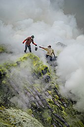
West of Gunung Merapi is the Ijen volcano, which has a one-kilometre-wide (0.62 mi) turquoise-coloured acidic crater lake. The lake is the site of a labour-intensive sulfur mining operation, in which sulfur-laden baskets are carried by hand from the crater floor. The work is paid well considering the cost of living in the area, but is very onerous.[3] Workers earn around US$13 per day and, once out of the crater, still need to carry their loads of sulfur chunks about three kilometers to the nearby Paltuding Valley to get paid.[4]
Many other post-caldera cones and craters are located within the caldera or along its rim. The largest concentration of post-caldera cones runs east–west across the southern side of the caldera. The active crater at Kawah Ijen has a diameter of 722 metres (2,369 ft) and a surface area of 0.41 square kilometres (0.16 sq mi). It is 200 metres (660 ft) deep and has a volume of 36 cubic hectometres (29,000 acre⋅ft).
The lake is recognised as the largest highly acidic crater lake in the world.[1] It is also a source for the river Banyupahit, resulting in highly acidic and metal-enriched river water which has a significant detrimental effect on the downstream river ecosystem.[5] During a scientific expedition in 2001, the pH of the lake was measured at <0.3. [6] On July 14–15, 2008, explorer George Kourounis took a small rubber boat out onto the acid lake to measure its acidity. The pH of the water at the lake's edges was measured to be 0.5 and in the middle of the lake 0.13 due to a high concentration of sulfuric acid.[7]
- ^ a b "Ijen". Global Volcanism Program. Smithsonian Institution. Retrieved 24 June 2021.
- ^ "Photos from inside the volcanic sulphur mines of Indonesia". news.com.au. 9 February 2015. Archived from the original on 11 November 2016. Retrieved 19 October 2017.
- ^ Lane, Megan (9 February 2011). "Sulphur mining in an active volcano". BBC News.
- ^ Harsaputra, Indra (19 December 2011). "Kawah Ijen: Between potential and threat". The Jakarta Post.
- ^ "University of Amsterdam, Faculty of Earth and Life Sciences, Natural Pollution Caused by the Extremely Acidic Crater Lake Kawah Ijen, East Java, Indonesia" (PDF). Retrieved 9 December 2013.
- ^ Löhr, Ansje; Bogaard, Thom; Heikens, Alex; Hendriks, Martin; Sumarti, Sri; Bergen, Manfred van; Gestel, Kees C.A.M. van; Straalen, Nico van; Vroon, Pieter; Widianarko, Budi (2005). "Natural Pollution Caused by the Extremely Acid Crater Lake Kawah Ijen, East Java, Indonesia (7 pp)". Environmental Science and Pollution Research International. 12 (2): 89–95. doi:10.1065/espr2004.09.118. PMID 15859115. S2CID 128470417.
- ^ Boating on acid
