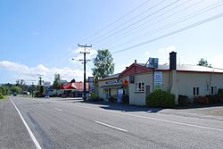
Ikamatua | |
|---|---|
town | |
 State Highway 7 passing through Ikamatua | |
| Coordinates: 42°16′17.13″S 171°41′3.77″E / 42.2714250°S 171.6843806°E | |
| Country | New Zealand |
| Region | West Coast |
| Territorial authority | Buller District |
| Electorates | West Coast-Tasman Te Tai Tonga |
| Time zone | UTC+12 (New Zealand Standard Time) |
| • Summer (DST) | UTC+13 (New Zealand Daylight Time) |
Ikamatua is a small village on the West Coast of the South Island in New Zealand. Its name translates literally as ika (fish) and matua (mature/parent). It may be a contraction of Te Ika-a-matua, fish of my ancestor.[1]
It is located on the State Highway 7 inland route, 50 kilometres (31 mi) north of Greymouth and 28 kilometres (17 mi) south of Reefton. It has a population of under 200.[2]
In 1946, 4 km north of Ikamatua, the floating Grey River gold dredge dug its way across State Highway 7, and the main Greymouth to Westport railway link, to move into its new mining area in the Blackwater Valley. This was the first and only time that such an event has occurred in New Zealand.[3]
In 1906 Ikamatua had two sawmills, a creamery, a railway station and a school.[4]
- ^ Reed, A. W. (1979). The Reed dictionary of New Zealand place names (2002 ed.). Auckland [N.Z.]: Reed. ISBN 0-7900-0761-4. OCLC 49290681.
- ^ "Ikamatua". Archived from the original on 13 May 2010. Retrieved 11 April 2010.
- ^ Latham, Darrell (1984). The Golden Reefs: an account of the great days of quartz-mining at Reefton, Waiuta and the Lyell. Christchurch: Pegasus Press. p. 417. ISBN 0908568126.
- ^ "The Cyclopedia of New Zealand - Ikamatua". nzetc.victoria.ac.nz. 1906. Retrieved 15 September 2022.
