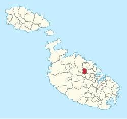
Iklin
L-Iklin | |
|---|---|
 Chapel of St. Michael Archangel built in 1615 | |
 | |
| Coordinates: 35°54′15″N 14°27′16″E / 35.90417°N 14.45444°E | |
| Country | |
| Region | Central Region |
| District | Western District |
| Established | 1954 |
| Area | |
• Total | 1.7 km2 (0.7 sq mi) |
| Population (Jan. 2019) | |
• Total | 3,422 |
| • Density | 2,000/km2 (5,200/sq mi) |
| Demonym(s) | Ikliniż (m), Ikliniża (f), Ikliniżi (pl) |
| Time zone | UTC+1 (CET) |
| • Summer (DST) | UTC+2 (CEST) |
| Postal code | IKL |
| Dialing code | 356 |
| ISO 3166 code | MT-19 |
| Patron saint | Holy Family St. Michael |
| Day of festa | Sunday before 29 September (St. Michael) |
| Website | Official website |

Iklin (Maltese: L-Iklin) is a village in the Central Region of Malta, with a population of 3,247 as at 2021. Iklin was established in the mid-20th century; however some archaeological sites[1] and a medieval chapel, named as St. Michael Chapel, are proof to earlier settlements. Until recently, the town was considered to form part of the Three villages of Malta, as part of Lija. With the separation of Iklin from Lija, Iklin is no longer part of the three villages.[2] It is bordered by Għargħur, San Ġwann, Birkirkara, Balzan and Naxxar.
Iklin is divided in Lower Iklin siding on the Birkirkara bypass and the Upper Iklin. In Lower Iklin houses are built side by side, in general villas and maisonettes but also recently some apartments. In Upper Iklin land is on a hill close to Naxxar and land is considered more expensive; in general the land consists of villas and farmhouses. The two sides share two common facts, the neighborhoods structural design and the general silence living areas.[3]
- ^ Sagona, Claudia (2015). The Archaeology of Malta. Cambridge University Press. p. 313. ISBN 9781107006690.
- ^ S. Formosa; S. Scicluna; J. Azzopardi (January 2013). Saviour Formosa; Sandra Scicluna; Jacqueline Azzopardi (eds.). Realities of Crime, Society and Landuse in the Mediterranean: JANUS I (PDF). Msida: Department of Criminology, University of Malta. p. 79. doi:10.13140/2.1.1230.4322. ISBN 978-99957-834-0-2. Archived from the original on 15 March 2017.
- ^ "Malta-The George Cross Island - "Towns & Villages" (3)". English-studies.org. Archived from the original on 5 March 2016. Retrieved 4 January 2016.

