 View of Ilha Grande from the mainland | |
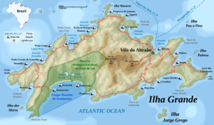
 English topographic map of Ilha Grande | |
| Geography | |
|---|---|
| Location | Atlantic Ocean |
| Coordinates | 23°09′S 44°14′W / 23.150°S 44.233°W |
| Area | 193 km2 (75 sq mi) |
| Highest elevation | 1,031 m (3383 ft) |
| Highest point | Pico da Pedra D'Água |
| Administration | |
| Municipality | Angra dos Reis |
| State | Rio de Janeiro |
| Demographics | |
| Population | ~5000 (2014) |
| Official name | Paraty and Ilha Grande – Culture and Biodiversity |
| Criteria | Cultural and Natural: (v), (x) |
| Designated | 2019 (43rd session) |
| Reference no. | 1308 |
| Region | Latin America and the Caribbean |
Ilha Grande (Portuguese pronunciation: [ˈiʎɐ ˈɡɾɐ̃dʒi]), or "big island", is a 193 km2 (75 sq mi) forested island located around 12 km (7.5 mi) off of the Atlantic coast of Angra dos Reis, Rio de Janeiro, Brazil, and about 243 km (151 mi) from São Paulo. The highest point on Ilha Grande is the 1,031 m (3,383 ft) tall Pico da Pedra D'Água.[1]
- ^ "Pico da Pedra D'Água, Brazil". Peakbagger. Retrieved 5 March 2024.