| Illinois Caverns State Natural Area | |
|---|---|
IUCN category V (protected landscape/seascape) | |
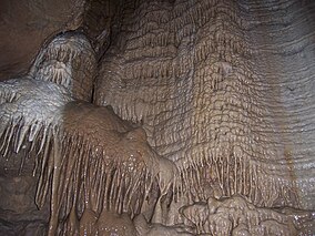
 Drapery and flowstone in Chimney Dome | |
Map of the U.S. state of Illinois showing the location of Illinois Caverns State Natural Area | |
| Location | Monroe County, Illinois, U.S. |
| Nearest city | Waterloo, Illinois |
| Coordinates | 38°14′08″N 90°08′13″W / 38.23556°N 90.13694°W |
| Area | 120 acres (49 ha) |
| Established | April 23, 1901 |
| Governing body | Illinois Department of Natural Resources |
Illinois Caverns is a state natural area in the New Design Precinct of Monroe County, Illinois. It features Illinois Caverns which is alternatively known as Mammoth Cave of Illinois (also Burksville Cave, Egyptian Cave, Eckert Cave). Illinois Caverns is the second-largest cave in Illinois and has more than 9.6 km of passages.[1] The cave has a constant temperature of 58 °F (14 °C), and portions flood during wet weather. Passages can be 20 feet (6.1 m) high and just as wide. It is located off Illinois Route 3, south of Waterloo, near the unincorporated community of Burksville.
- ^ Panno, S.V.; S.E. Greenberg; C.P. Weibel; P.K. Gillespie (2003). A Guide to the Illinois Caverns State Natural Area. Illinois State Geological Survey GeoScience Education Series. p. 66.

