You can help expand this article with text translated from the corresponding article in Finnish. (January 2022) Click [show] for important translation instructions.
|
Ilomantsi
Ilomants | |
|---|---|
Municipality | |
| Ilomantsin kunta Ilomants kommun | |
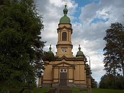
 Church of Saint Prophet Elijah | |
 Location of Ilomantsi in Finland | |
| Coordinates: 62°40′N 030°56′E / 62.667°N 30.933°E | |
| Country | |
| Region | North Karelia |
| Sub-region | Joensuu |
| Charter | 1875 |
| Government | |
| • Municipal manager | Markku Lappalainen |
| Area (2018-01-01)[1] | |
• Total | 3,172.69 km2 (1,224.98 sq mi) |
| • Land | 2,763.4 km2 (1,067.0 sq mi) |
| • Water | 409.01 km2 (157.92 sq mi) |
| • Rank | 19th largest in Finland |
| Population (2024-10-31)[2] | |
• Total | 4,372 |
| • Rank | 183rd largest in Finland |
| • Density | 1.58/km2 (4.1/sq mi) |
| Population by native language | |
| • Finnish | 95.4% (official) |
| • Swedish | 0.2% |
| • Others | 4.4% |
| Population by age | |
| • 0 to 14 | 8.9% |
| • 15 to 64 | 50.1% |
| • 65 or older | 41% |
| Time zone | UTC+02:00 (EET) |
| • Summer (DST) | UTC+03:00 (EEST) |
| Website | www |
Ilomantsi (Karelian: Il'manči or Ilomančči, Swedish: Ilomants) is municipality and a village of Finland. It is located in the North Karelia region. The municipality has a population of 4,372 (31 October 2024)[2] and covers an area of 3,172.69 square kilometres (1,224.98 sq mi) of which 409.01 km2 (157.92 sq mi) is water.[1] The population density is 1.58 inhabitants per square kilometre (4.1/sq mi). The easternmost point of Finland and the continental part of the European Union is located in Ilomantsi near the village of Hattuvaara. (In the EU, only Cyprus is located further to the east.)
The nearest town is Joensuu, 72 kilometres (45 mi) away; the distance to Helsinki is 511 km (318 mi). Neighbouring municipalities are Lieksa and Joensuu. In the east, Ilomantsi shares 100 km (60 mi) long border with the Russian Republic of Karelia. The municipality is sparsely populated and is mostly characterized by forests and boglands. About 250 km2 (97 sq mi) of the area is designated as natural reserves, among them the national parks Petkeljärvi and Patvinsuo. The most important bodies of water in Ilomantsi are the lakes Koitere and Nuorajärvi and the river Koitajoki. The Pampalo gold mine is located in Ilomantsi.[5][6]
The municipality is unilingually Finnish. Local words of Karelian or Russian extraction might be used in Ilomantsi. For example, the central village of the municipality is not called kirkonkylä as is usual in Finland, but pogosta (a Russian loan-word, originally pogost).[citation needed] Even the local newspaper is called Pogostan Sanomat, i.e. "The Pogosta News".[7]
Ilomantsi has 17.4% Orthodox minority, which is the largest percentage among Finnish municipalities. The wooden Orthodox church of Ilomantsi is the largest in Finland and is dedicated to the prophet Elijah. There are also five Orthodox chapels (tsasouna) in the municipality. The Orthodox community of Ilomantsi is more than 500 years old and counts 1,100 members.
- ^ a b "Area of Finnish Municipalities 1.1.2018" (PDF). National Land Survey of Finland. Retrieved 30 January 2018.
- ^ a b c "Finland's preliminary population figure was 5,635,560 at the end of October 2024". Population structure. Statistics Finland. 19 November 2024. ISSN 1797-5395. Retrieved 22 November 2024.
- ^ "Population according to age (1-year) and sex by area and the regional division of each statistical reference year, 2003–2020". StatFin. Statistics Finland. Retrieved 2 May 2021.
- ^ a b "Luettelo kuntien ja seurakuntien tuloveroprosenteista vuonna 2023". Tax Administration of Finland. 14 November 2022. Retrieved 7 May 2023.
- ^ Pampalo - Mineral Deposit Report – Geological Survey of Finland
- ^ Pampalon kultakaivoksen toiminta on alkanut lupaavasti – kullan hinta on nyt riittävällä tasolla toiminnan pyörittämiseen – Yle (in Finnish)
- ^ "Pogostan Sanomat". pogostansanomat.fi (in Finnish). Retrieved 12 July 2023.
