Imbaba
إمبابة | |
|---|---|
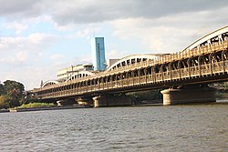
 An old photo of the Imbaba bridge | |
| Coordinates: 30°5′33″N 31°12′2″E / 30.09250°N 31.20056°E | |
| Country | |
| Governorate | Giza Governorate |
| Area | |
• Total | 3.20 sq mi (8.28 km2) |
| Population | |
• Total | 1,465,875 |
| • Density | 460,000/sq mi (180,000/km2) |
| approximately | |
| Time zone | UTC+2 (EST) |
Imbaba (Arabic: إمبابة Imbāba, IPA: [emˈbæːbæ]) is a working-class neighbourhood in northern Giza, Egypt, located west of the Nile and northwest of and near Gezira Island and downtown Cairo, within the Giza Governorate. The district is located in the historic upper Nile Delta, and is part of the Greater Cairo metropolitan area. Imbaba is the most densely populated city subdivision in the world.
Imbaba is also the name of an adjacent administrative centre (مركز) in rural Giza Governorate, which has 18 villages in its jurisdiction.[1]
