Imperatriz, Maranhão | |
|---|---|
Municipality | |
| The Municipality of Imperatriz | |
 | |
| Nickname: Portal da Amazônia (Amazon Portal) | |
| Motto(s): Paz e Progresso (Peace and Progress) | |
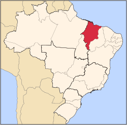
 Location of Imperatriz in the State of Maranhão | |
 | |
| Country | |
| Region | Northeast |
| State | |
| Founded | July 16, 1856 |
| Government | |
| • Mayor | Assis Ramos (PSDB) |
| Area | |
| • Municipality | 1,367.9 km2 (528.1 sq mi) |
| Elevation | 95 m (312 ft) |
| Population (2020 [1]) | |
| • Municipality | 259,337 (110 th) |
| • Metro | 526,116 |
| Time zone | UTC-3 (UTC-3) |
| • Summer (DST) | UTC-2 (UTC-2) |
| Postal code | 65900-000 |
| Area code | +55 99 |
| HDI (2000) | 0.722 – high |
| Website | Imperatriz, Maranhão |
Imperatriz is the second most populated city in the Brazilian state of Maranhão. The city extends along the northeastern bank of the Tocantins River and is crossed by the Belém-Brasília Highway, standing on the border with the state of Tocantins.

