| Incahuasi | |
|---|---|
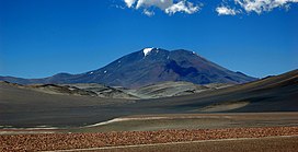
 Incahuasi volcano as seen from route 60, Fiambala, Argentina | |
| Highest point | |
| Elevation | 6,621 or 6,638 m (21,722 or 21,778 ft)[1][2] |
| Prominence | 1,518 m (4,980 ft)[1] |
| Listing | Ultra |
| Coordinates | 27°01′59″S 68°17′46″W / 27.033°S 68.296°W[2] |
| Geography | |
| Location | Catamarca, Argentina - Atacama, Chile |
| Parent range | Andes |
| Geology | |
| Mountain type(s) | stratovolcanoes and caldera |
| Last eruption | Unknown |
| Climbing | |
| First ascent | 1913 by Walther Penck |
Incahuasi (Spanish pronunciation: [iŋkaˈwasi]; possibly from Quechua: inka Inca, wasi house)[3][4] is a volcanic mountain in the Andes of South America. It lies on the border of the Catamarca Province of Argentina and the Atacama Region of Chile. Incahuasi has a summit elevation of 6,621 metres (21,722 ft) above sea level.
The volcano consists of a 3.5-kilometre-wide (2.2 mi) caldera and two stratovolcanoes. Four pyroclastic cones located 7 kilometres (4.3 mi) to the northeast have produced basalt-andesite lava flows that cover an area of 10 square kilometres (4 sq mi).[5]
- ^ a b "Argentina and Chile North: Ultra-Prominences" Peaklist.org. Retrieved 2013-02-25.
- ^ a b Cite error: The named reference
GVPwas invoked but never defined (see the help page). - ^ Diccionario Quechua - Español - Quechua, Academía Mayor de la Lengua Quechua, Gobierno Regional Cusco, Cusco 2005 (Quechua-Spanish dictionary)
- ^ Teofilo Laime Ajacopa, Diccionario Bilingüe Iskay simipi yuyayk'ancha, La Paz, 2007 (Quechua-Spanish dictionary)
- ^ "Nevado de Incahuasi Volcano, Chile/Argentina | John Seach".
