| Scottish Gaelic name | Innis Choluim |
|---|---|
| Meaning of name | Island of St Columba |
 Inchcolm and Braefoot Bay | |
| Location | |
| OS grid reference | NT189827 |
| Coordinates | 56°02′N 3°18′W / 56.03°N 3.30°W |
| Physical geography | |
| Island group | Islands of the Forth |
| Area | 9 hectares (22 acres) |
| Highest elevation | 34 metres (112 feet) |
| Administration | |
| Council area | Fife |
| Country | Scotland |
| Sovereign state | United Kingdom |
| Demographics | |
| Population | 2[1] |
| References | [2][3][4][5] |

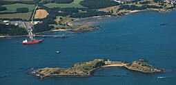
Inchcolm (from the Scottish Gaelic "Innis Choluim", meaning Columba's Island) is an island in the Firth of Forth in Scotland. The island has a long history as a site of religious worship, having started with a church, which later developed into a monastery and a large Augustine Abbey in the mid 13th century. It was repeatedly attacked by English raiders during the Wars of Scottish Independence, and was later fortified extensively with gun emplacements and other military facilities during both World Wars to defend nearby Edinburgh.
Inchcolm Abbey and the surrounding island are now in the care of Historic Scotland. The island is accessible to visitors during the day via private boat tours from Queensferry. Many of the religious buildings on Inchcolm remain in fair condition and Inchcolm is described as having the best-preserved cloister in Scotland.[6]
- ^ National Records of Scotland (15 August 2013). "Appendix 2: Population and households on Scotland's Inhabited Islands" (PDF). Statistical Bulletin: 2011 Census: First Results on Population and Household Estimates for Scotland Release 1C (Part Two) (PDF) (Report). SG/2013/126. Retrieved 14 August 2020.
- ^ Haswell-Smith, Hamish (2004). The Scottish Islands. Edinburgh: Canongate. ISBN 978-1-84195-454-7.
- ^ Ordnance Survey
- ^ Iain Mac an Tailleir. "Placenames" (PDF). Pàrlamaid na h-Alba. Archived from the original (PDF) on 10 April 2008. Retrieved 27 July 2007.
- ^ Area estimate from Morris, Ron (2003) "The Wildlife of Inchcolm :" [permanent dead link] Hillside. Retrieved 23 June 2008.
- ^ Inchcolm Abbey and Island. Historic Scotland. 2011. p. 10. ISBN 978-1-84917-257-8.
