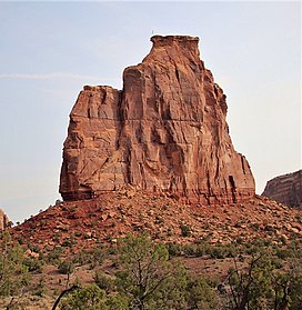
| Independence Monument | |
|---|---|
| Independence Rock[1] | |
 South aspect | |
| Highest point | |
| Elevation | 5,739 ft (1,749 m)[2] |
| Prominence | 379 ft (116 m)[2] |
| Parent peak | The Island (5,770 ft)[3] |
| Isolation | 0.26 mi (0.42 km)[3] |
| Coordinates | 39°05′45″N 108°43′24″W / 39.0958148°N 108.7234324°W[1] |
| Geography | |
| Country | United States |
| State | Colorado |
| County | Mesa |
| Protected area | Colorado National Monument |
| Parent range | Colorado Plateau Uncompahgre Plateau[2] |
| Topo map | USGS Colorado National Monument |
| Geology | |
| Age of rock | Late Triassic to Early Jurassic[4] |
| Type of rock | Wingate Sandstone |
| Climbing | |
| First ascent | June 14, 1911 John Otto |
| Easiest route | class 5.9- climbing[3] |
Independence Monument is a 5,739-foot-elevation (1,749 meter) sandstone pillar located in Colorado National Monument, in Mesa County of western Colorado, United States.[1] This iconic 450-foot-high landmark is situated one mile southeast of the monument's visitor center, and 9 miles (14 km) west of the community of Grand Junction, where it towers above the floor of Monument Canyon and Wedding Canyon.[5] It is a popular climbing destination, and can be seen from Rim Rock Drive.
- ^ a b c "Independence Monument". Geographic Names Information System. United States Geological Survey, United States Department of the Interior. Retrieved 2021-03-16.
- ^ a b c "Independence Monument, Colorado". Peakbagger.com. Retrieved 2021-03-16.
- ^ a b c "Independence Monument - 5,739' CO". listsofjohn.com. Retrieved 2021-03-16.
- ^ Geologic Formations, National Park Service
- ^ Freedom Flies High, National Park Service

