Indian Heights, Indiana | |
|---|---|
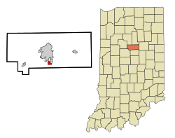
 Location in the state of Indiana | |
| Coordinates: 40°25′43″N 86°7′7″W / 40.42861°N 86.11861°W | |
| Country | United States |
| State | Indiana |
| County | Howard |
| Area | |
• Total | 0.9 sq mi (2.2 km2) |
| • Land | 0.9 sq mi (2.2 km2) |
| • Water | 0.0 sq mi (0.0 km2) |
| Elevation | 856 ft (261 m) |
| Population (2010) | |
• Total | 3,011 |
| • Density | 3,807/sq mi (1,469.9/km2) |
| Time zone | UTC-5 (EST) |
| • Summer (DST) | UTC-4 (EDT) |
| FIPS code | 18-36144[1] |
| GNIS feature ID | 0436762[2] |
Indian Heights is a neighborhood in Kokomo, Howard County, Indiana, United States. Indian Heights was a census-designated place (CDP) also before its annexation into Kokomo. The population was 3,011 at the 2010 census. It is part of the Kokomo, Indiana Metropolitan Statistical Area. On January 1, 2012, the neighborhood of Indian Heights was legally annexed into the city of Kokomo's corporate boundary.
[3]Mohawk park the only park in the region, however, Taylor Elementary School has a playground in the back of the school. There are neighborhoods such as Ojibway, Miami, Algonquin and Mohawk being the most famous. They're named after native American tribes.
- ^ "U.S. Census website". United States Census Bureau. Retrieved January 31, 2008.
- ^ "US Board on Geographic Names". United States Geological Survey. October 25, 2007. Retrieved January 31, 2008.
- ^ "Annexation - City of Kokomo Indiana - Kokomo, IN". Archived from the original on March 11, 2014. Retrieved January 17, 2012.