Indo-Gangetic Plain | |
|---|---|
Geographical region | |
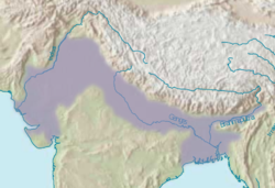
 Map of the Indo-Gangetic Plain | |
| Country | India, Pakistan, Bangladesh, Nepal |
| Area | |
• Total | 700,000 km2 (300,000 sq mi) |
The Indo-Gangetic Plain, also known as the Northern Plain or North Indian River Plain, is a fertile plain spanning 700,000 km2 (270,000 sq mi) across the northern and north-eastern part of the Indian subcontinent. It encompasses northern and eastern India, eastern Pakistan, southern Nepal, and almost all of Bangladesh. It is named after the two major river systems that drain the region–Indus and Ganges.
Its stretches from the Himalayas in the north to the northern edge of the Deccan plateau in the south, and extends from North East India in the east to the Iranian border in the west. The region is home to many major cities and nearly one-seventh of the world's population. As the region was formed by the deposits of the three major rivers–Indus, Ganges and Brahmaputra, the plains consists of the world's largest expanse of uninterrupted alluvium. Due to its rich water resources, it is one of the world's most densely populated and intensely farmed areas.