Indre | |
|---|---|
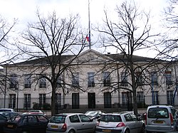
 Prefecture building of the Indre department, in Châteauroux | |
 Location of Indre in France | |
| Coordinates: 46°46′N 1°36′E / 46.767°N 1.600°E | |
| Country | France |
| Region | Centre-Val de Loire |
| Prefecture | Châteauroux |
| Subprefectures | Le Blanc La Châtre Issoudun |
| Government | |
| • President of the Departmental Council | Marc Fleuret[1] (UDI) |
| Area | |
| • Total | 6,791 km2 (2,622 sq mi) |
| Population (2021)[2] | |
| • Total | 217,228 |
| • Rank | 88th |
| • Density | 32/km2 (83/sq mi) |
| Time zone | UTC+1 (CET) |
| • Summer (DST) | UTC+2 (CEST) |
| Department number | 36 |
| Arrondissements | 4 |
| Cantons | 13 |
| Communes | 241 |
| ^1 French Land Register data, which exclude estuaries, and lakes, ponds, and glaciers larger than 1 km2 | |
Indre (French pronunciation: [ɛ̃dʁ] ); is a department in central France named after the river Indre. The inhabitants of the department are known as the Indriens (masculine; pronounced [ɛ̃dʁijɛ̃]) and Indriennes (feminine; [ɛ̃dʁijɛn]). Indre is part of the current administrative region of Centre-Val de Loire. The region is bordered by the departments of Indre-et-Loire to the west, Loir-et-Cher to the north, Cher to the east, Creuse and Haute-Vienne to the south, and Vienne to the southwest. The préfecture (capital) is Châteauroux and there are three subpréfectures at Le Blanc, La Châtre and Issoudun. It had a population of 219,316 in 2019.[3] It also contains the geographic centre of Metropolitan France.
- ^ "Répertoire national des élus: les conseillers départementaux". data.gouv.fr, Plateforme ouverte des données publiques françaises (in French). 4 May 2022.
- ^ "Téléchargement du fichier d'ensemble des populations légales en 2021" (in French). The National Institute of Statistics and Economic Studies. 28 December 2023.
- ^ Populations légales 2019: 36 Indre, INSEE

