This article needs additional citations for verification. (June 2009) |
| Ingatestone | |
|---|---|
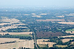
 Aerial view of Ingateston | |
Location within Essex | |
| Population | 5,409 |
| OS grid reference | TQ645995 |
| Civil parish | |
| District | |
| Shire county | |
| Region | |
| Country | England |
| Sovereign state | United Kingdom |
| Post town | INGATESTONE |
| Postcode district | CM4 |
| Dialling code | 01277 |
| Police | Essex |
| Fire | Essex |
| Ambulance | East of England |
| UK Parliament | |
Ingatestone is a village and former civil parish in Essex, England, with a population of 5,409 inhabitants at the 2021 Census. Just north lies the village of Fryerning; the two now forming the parish of Ingatestone and Fryerning, in the Borough of Brentwood. Ingatestone lies in the Metropolitan Green Belt 20 miles (32 km) north-east of London. Its built-up area straddles the A12 trunk road and the Great Eastern Main Line railway.
