This article needs additional citations for verification. (October 2017) |
Ingiriya
ඉංගිරිය இங்கிரிய | |
|---|---|
 Ingiriya | |
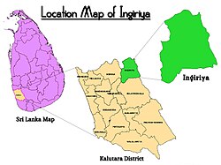
 Ingiriya Location Map | |
| Coordinates: 6°44′38″N 80°10′20″E / 6.74389°N 80.17222°E | |
| Country | Sri Lanka |
| Province | Western Province |
| District | Kalutara District |
| Government | |
| • Electoral Division | Horana Polling Division |
| • Local Government | Horana Pradeshiya Sabha |
| • Divisional Secretariat | Ingiriya Divisional Secretariat |
| Elevation | 137 m (449 ft) |
| Population (2017) | |
• Total | 56,074 |
| • Density | 252.66/km2 (654.4/sq mi) |
| Time zone | UTC+05:30 (SLT) |
| Postal Code | |
| Telephone code | 0094-3422 XXXXX |
| Website | www |
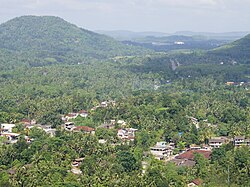
Ingiriya (Sinhala: ඉංගිරිය; Tamil: இங்கிரிய) is a city in Kalutara District of Western Province, Sri Lanka, near the border with Sabaragamuwa Province. The city is the meeting point of the Rathnapura–Panadura, Ingiriya–Padukka and Ingiriya–Bulathsinhala roads.
The city has an ethnic makeup of 89.7% Sinhalese and 10.1% Tamils, with less than 1% from other ethnicity. The 2001 census recorded a population of 45,726, rising to 56,074 in 2017.[1]
- ^ Census and Statistics Report 2017
