This article's tone or style may not reflect the encyclopedic tone used on Wikipedia. (May 2024) |
| Inks Lake State Park | |
|---|---|
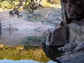
 Devil's Waterhole in Inks Lake State Park | |
 | |
| Location | Burnet County, Texas |
| Nearest city | Burnet |
| Coordinates | 30°43′52″N 98°22′14″W / 30.73111°N 98.37056°W |
| Area | 1,201 acres (486 ha) |
| Established | 1950 |
| Visitors | 232,690 (in 2022)[1] |
| Governing body | Texas Parks and Wildlife Department |
| Website | Official website |
Inks Lake State Park is a state park located in Burnet County, Texas, United States, next to Inks Lake on the Colorado River. It contains facilities for swimming, camping, hiking, boating, fishing and general enjoyment of the natural beauty.[2] The landscape consists mainly of hills and includes both forest and cleared land made up of mainly gneiss rock. Containing plants such as cedar, live oak, prickly pear cacti, and yuccas. Devil's Waterhole is a small extension of Inks Lake, which is almost completely surrounded by rock.[3]
- ^ Christopher Adams (February 24, 2023). "What is the most visited state park in Texas? Here's the top 10 countdown". KXAN.com. Archived from the original on November 22, 2023. Retrieved November 21, 2023.
- ^ "Inks Lake State Park | Nature Rocks Austin". naturerocksaustin.org. Retrieved July 21, 2024.
- ^ Cite error: The named reference
:0was invoked but never defined (see the help page).