| Inman Valley South Australia | |||||||||||||||
|---|---|---|---|---|---|---|---|---|---|---|---|---|---|---|---|
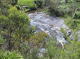
 Glaciated pavement in the Inman River | |||||||||||||||
| Coordinates | 35°29′43″S 138°27′18″E / 35.49526°S 138.454944°E[1] | ||||||||||||||
| Population | 343 (2016 census)[2] | ||||||||||||||
| Postcode(s) | 5211[3] | ||||||||||||||
| Location | 86 km (53 mi) South of Adelaide | ||||||||||||||
| LGA(s) | |||||||||||||||
| Region | Fleurieu and Kangaroo Island[4] | ||||||||||||||
| County | Hindmarsh[1] | ||||||||||||||
| State electorate(s) | Finniss[5] Mawson[6] | ||||||||||||||
| Federal division(s) | Mayo[7] | ||||||||||||||
| |||||||||||||||
| |||||||||||||||
| Footnotes | Adloining localities[1] | ||||||||||||||
Inman Valley is a locality in the Australian state of South Australia located on the Fleurieu Peninsula about 86 kilometres (53 mi) south of the state capital of Adelaide. The valley is about 380 square kilometres (150 sq mi) in area. At the 2016 census, Inman Valley had a population of 343.[2]
- ^ a b c d e "Search results for 'Inman Valley, LOCB' with the following datasets being selected – 'Suburbs and Localities', 'Counties', 'Local Government Areas', 'SA Government Regions' and 'Gazetteer'". Location SA Map Viewer. Government of South Australia. Retrieved 6 March 2019.
- ^ a b Australian Bureau of Statistics (27 June 2017). "Inman Valley (State Suburb)". 2016 Census QuickStats. Retrieved 6 March 2019.
- ^ "Postcode for Inman Valley, South Australia". Retrieved 6 March 2019.
- ^ "Fleurieu Kangaroo Island SA Government region" (PDF). The Government of South Australia. Retrieved 17 April 2017.
- ^ Finniss (Map). Electoral District Boundaries Commission. 2016. Retrieved 2 March 2018.
- ^ Mawson (Map). Electoral District Boundaries Commission. 2016. Retrieved 2 March 2018.
- ^ "Profile of the electoral division of Mayo (SA)". Australian Electoral Commission. 20 July 2018. Retrieved 4 March 2019.
- ^ a b c "Summary (climate) Summary statistics MYPONGA (nearest weather station)". Commonwealth of Australia, Bureau of Meteorology. Retrieved 4 March 2019.
