| Insular Mountains | |
|---|---|
| French: Monts Insulaires | |
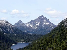
 Golden Hinde, south aspect, August 2006. | |
| Highest point | |
| Peak | Golden Hinde, Vancouver Island |
| Elevation | 2,196.818 m (7,207.41 ft) |
| Coordinates | 49°39′43.8″N 125°44′48.6″W / 49.662167°N 125.746833°W |
| Dimensions | |
| Area | 133,879 km2 (51,691 sq mi) |
| Geography | |
| Country | Canada |
| Province | British Columbia |
| Parent range | Pacific Cordillera |
The Insular Mountains are a range of mountains in the Pacific Coast Ranges on the Coast of British Columbia, Canada, comprising the Vancouver Island Ranges and Queen Charlotte Mountains. The Insular Mountains are rugged, particularly on Vancouver Island where peaks in Strathcona Provincial Park rise to elevations of more than 2,000 m (6,562 ft). The highest of these mountains is Golden Hinde on Vancouver Island, which rises to 2,196.818 m (7,207 ft).
Although the Coast Mountain Range is usually referred to as the westernmost range of the Pacific Cordillera (since it is the westernmost range on the main landmass at that point), the Insular Mountains are the true westernmost range.[1]
- ^ Coast Mountains in the Canadian Mountain Encyclopedia. Retrieved 8 October 2007
