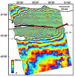
Interferometric synthetic aperture radar, abbreviated InSAR (or deprecated IfSAR), is a radar technique used in geodesy and remote sensing. This geodetic method uses two or more synthetic aperture radar (SAR) images to generate maps of surface deformation or digital elevation, using differences in the phase of the waves returning to the satellite[1][2][3] or aircraft. The technique can potentially measure millimetre-scale changes in deformation over spans of days to years. It has applications for geophysical monitoring of natural hazards, for example earthquakes, volcanoes and landslides, and in structural engineering, in particular monitoring of subsidence and structural stability.

- ^ Massonnet, D.; Feigl, K. L. (1998), "Radar interferometry and its application to changes in the earth's surface", Rev. Geophys., vol. 36, no. 4, pp. 441–500, Bibcode:1998RvGeo..36..441M, doi:10.1029/97RG03139, S2CID 24519422
- ^ Burgmann, R.; Rosen, P.A.; Fielding, E.J. (2000), "Synthetic aperture radar interferometry to measure Earth's surface topography and its deformation", Annual Review of Earth and Planetary Sciences, vol. 28, pp. 169–209, Bibcode:2000AREPS..28..169B, doi:10.1146/annurev.earth.28.1.169
- ^ Hanssen, Ramon F. (2001), Radar Interferometry: Data Interpretation and Error Analysis, Kluwer Academic, ISBN 9780792369455