Interlake Region | |
|---|---|
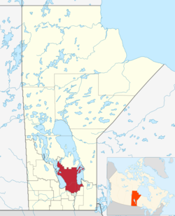
 Map of the Interlake Region of Manitoba. | |
| Country | |
| Province | |
| Area | |
| • Total | 15,858.13 km2 (6,122.86 sq mi) |
| Population | |
| • Total | 98,028 |
| • Density | 6.2/km2 (16/sq mi) |
The Interlake Region is an informal geographic region of the Canadian province of Manitoba that lies roughly between Lake Winnipeg and Lake Manitoba in the Canadian province of Manitoba.
The region comprises 14 rural municipalities, one city (the City of Selkirk), five towns (Arborg, Riverton, Stonewall, Teulon and Winnipeg Beach) ,and one village (Dunnottar). The largest population centre in the region is Selkirk, and the second largest is the town of Stonewall.
Argyle, Manitoba, is the small hamlet that is located on the Principal Meridian of Canada, near the middle of the Interlake Region. Sandy Hook is located between Winnipeg Beach and Gimli, a popular summer vacation spot.
- ^ "Interlake economic region statistics". Statistics Canada. Retrieved March 24, 2023.